Teardrop Lake

After a recent hike one of my coworkers asked about going on another winter hike. I didn’t have any more winter geocaches on my list so I suggested a trip to Killarney. Geocache or not, I like to have a destination so I decided to combine two adventures in Killarney park that have intrigued me for some time. We were going to try to make it to Teardrop Lake via the decommissioned portage from George Lake to OSA Lake.

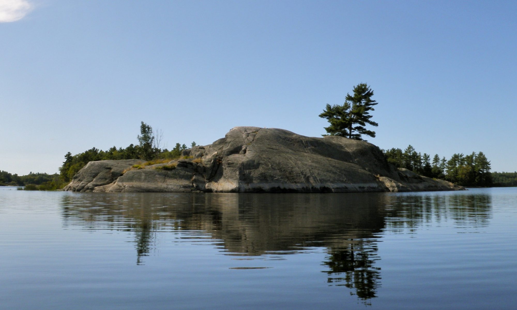
I’ve done some ridge running on the north shore of OSA Lake in the past in pursuit of a Geocache. It’s a spectacular location and I’ve returned twice to enjoy the view, but I decided that the next time I returned to OSA I’d try something different. While browsing the park map I noticed Teardrop Lake nestled high in the hills above OSA. There are no portages or trails leading to Teardrop so it’s one of the more remote lakes in the park. A little research revealed that it has been visited recently and isn’t particularly difficult to get to once on OSA Lake.

The George To OSA Portage

The normal route from George Lake to OSA Lake is to make multiple portages from George to Freeland, Freeland to Killarney, and finally from Freeland Lake to OSA Lake. This is a very scenic trip, but there’s a more direct route I’ve heard about in books, on the web and via word of mouth. There’s an old portage from George Lake directly to OSA Lake that was decommissioned years ago. It cuts straight across Killarney Ridge.

The old portage is reputedly quite difficult, and the park staff discourage its use to allow the area to regenerate, so I had no intention of carrying a canoe across the ridge, but it seemed like a great way to shorten a snowshoe trip to OSA Lake.

The Weather

Despite forecasts that called for a gloomy day we had almost perfect weather with not a cloud in the sky. The temperature hovered around -9°C which helped to keep us from overheating, but not so cold that we got chilled. There was a bit of wind on George Lake, but other than the occasional cold hand or ear we were pretty comfortable.

The Silhouette Trail

The First Hill

I decided to start the trip on the Silhouette Trail since it would minimize the time we were on the ice of George Lake and would also shorten the walk slightly. The Silhouette Trail circumnavigates the entire park. I’ve hiked short sections of it before, but never the start of the trail in George Lake Campground. The entire trail is quite rugged and the start of the trail is quite steep, as if to serve as a warning to unwary hikers.

Silhouette Trail

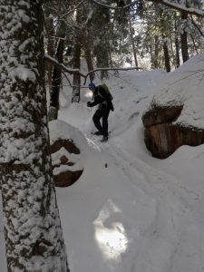
After walking through the car campground (the roads aren’t maintained in the winter) we put on our snowshoes at the trailhead and started to climb the first hill. Despite the steep slope there was a toboggan trail leading up the hill and continuing along the trail. We suspected a camper, and between AY Jackson Lake and Little Sheguiandah  Lake we encountered a lone man dragging a sled laden with gear. He had a four season tent and I assume a winter sleeping bag, not a Snow Trekker Tent and wood stove, so he was in for a cold night. Winter camping is pretty hardcore, but doing it solo is extreme!

Once we passed the camper we were breaking trail through fresh snow which made walking more difficult. The trail is rugged enough that our ‘shortcut’ to Little Sheguiandah probably didn’t save us any time, but it was very scenic. I’ll probably return to hike the entire Cranberry Bog trail in the future because it is very nice.

Little Sheguiandah Lake

Despite the rough terrain it didn’t take us long at all to reach Little Sheguiandah Lake, and neither of us were particularly winded which was a good sign since we had yet to begin the difficult part of the trip. As we crossed the ice we were quite surprised to see another hiker on the far side of the little lake. He’d hiked along the ice of George Lake and was travelling in the direction opposite to us.

Little Sheguiandah Lake is very pretty, and also holds some special significance for me so we stopped to take some pictures and enjoy the spot. After that we crossed George Lake to where I thought the trailhead was on the far side. The wind had compacted the snow on the ice making it much easier to walk on than in the woods.

Getting Lost

We headed for the northeast corner of the bay on the far side of the lake and then circled west to find the portage. I’d done a fair amount of research on how to find the trail, but it had been a few weeks since I read any of it so I couldn’t remember exactly where we should be searching. With all of the snow on the ground we couldn’t find anything resembling a trail, marked or unmarked. After searching for a while I decided to just head into the sparse brush and climb upslope. I reasoned that as the valley funnelled us to the pass between the peaks at the top we’d be sure to encounter the trail.

I soon realized that we were on the wrong side of a creek that was heading up the mountain to our left. We crossed the shallow stream after jumping down a steep embankment, but the hills of the valley kept steering us along the path of the creek and leading us away from where I felt the portage had to be.

Since we were now far from any trails and human travel we were surrounded by animal tracks. I decided to forego the sketchy advice of my GPSr and followed a heavily travelled deer trail that was heading up a pass and up the hill towards the light. The deer led us out of the valley but even they continued on up the wrong mountain. We were now so far off course that we were closer to Teardrop Lake than to the lost portage so I decided to change direction and head directly to our destination by climbing a hill to the north.

The snow was deeper in the woods than on the lake, and after an hour of breaking trail my legs were exhausted. I could barely lift my feet, and every time I’d settle my foot into the snow it would all collapse and leave me no higher than before. Mike offered to lead a bit and practically ran up the hill. He leapt from one foothold to the next, packing the snow down before it had a chance to crumble. I was easily able to climb the stairs Mike had carved into the steep slope of the hill, and we paused at the top for some lunch and to reorient ourselves.

After eating I tried to pull out the paper map but my hands had grown so stiff while I was eating that I couldn’t manipulate the folds of the paper. I finally realized that the two peaks to our north bounded the pass between us and Teardrop Lake. I quickly put my gloves back on and thankfully my numb hands soon warmed up.

The small hill where we’d paused for lunch represented a turning point. We were tantalizingly close to our goal, but it was also getting late in the day. From here we could easily head back down the hill to George Lake, whereas pressing on would bring us even deeper into the park. Earlier I had decided that I’d be fine with not reaching Teardrop Lake as long as I got a nice view of OSA. So far we’d had neither, and the hike up the hill had been nice, but devoid of the kind of views that Killarney is famous for.

We decided to press on to Teardrop and tried to head north. The ridges of rock were not obliging however and kept pushing us in the wrong direction. Then we had to drop down below the trees and I couldn’t see the two peaks. I was using an old GPSr since my Oregon is damaged, and while our destination was out of sight it started to act up, reporting our location everywhere but where we were. This caused us to travel several hundred meters too far west before we got headed in the right direction. Then the bush in the bottom of the valley was so dense that we had to climb the right peek slightly in order to get through.

Teardrop Lake

We were pretty tired by the time we stumbled down the steep hill to Teardrop Lake, making our destination a bit anticlimactic. Teardrop is in fact a very pretty lake, surrounded by tall cliffs like Topaz Lake, but after some of the other places we’d been it was almost disappointing. We walked to the north shore hoping to get a glimpse of OSA Lake, but the view was in the wrong direction and we were too tired to climb any higher.

We didn’t want to return the way we’d come, and I was hoping we could still find the old portage to make the return trip easier. To get there we had to climb a very steep hill leading out of Teardrop, and to my surprise we found ourselves at the peak of one of the hills along the ridge. We still couldn’t see OSA Lake, but we had a spectacular view of Teardrop and the LaCloche hills to the north.

Getting Off The Mountain

Mike looks out as we prepare to climb down.

We continued along the top of the mountain and each turn presented us with a new spectacular view. We could see our footprints from earlier in the day on the snow of George Lake far below us to the south, and further afield we could see Georgian Bay, Phillip Edward Island and Manitoulin Island. The setting sun was also lighting the peak of Killarney Ridge to the northeast which was our destination since I thought that the portage trail ran along the base of the mountain. We even finally got our view of OSA Lake, and were able to see Killarney Lake to the north and The Crack. If Silver Peek was visible I couldn’t figure out which one it was.

We’d worked so hard to get a view of OSA Lake and now it seemed we couldn’t get away from it. The mountain kept pushing us north towards OSA, and not George where we had to go. Every time we descended a slope I was surprised by how high we still were. I hadn’t realized that we’d climbed so far up. The descent become steeper and steeper until we found ourselves peering over a cliff face at a valley below. We debated attempting a treacherous descent or heading back up the mountain to find a more gradual slope, but eventually opted for the easier but riskier option of zigzagging down the steep slope and using trees for support.

Looking South Soon After Sunset

It was surprisingly easy to get down to the valley floor, but after all of the downhill sliding my snowshoes felt like they were made of lead as I tried to walk on level ground again. The sun had just set but we still had about a half hour of light before dark. We finally made it to where I knew the old portage had to be, but we still couldn’t find the trail, so we just trudged through the pass in the direction of George Lake. At this point I had so much ice on my GPSr that I couldn’t manipulate the buttons anymore, but I could at least tell what direction we should be heading.

The Long Walk Home

It was surprisingly easy to get down to the valley floor, but after all of the downhill sliding my snowshoes felt like they were made of lead as I tried to walk on level ground again. The sun had just set but we still had about a half hour of light before dark. We finally made it to where I knew the old portage had to be, but we still couldn’t find the trail, so we just trudged through the pass in the direction of George Lake. At this point I had so much ice on my GPSr that I couldn’t manipulate the buttons anymore, but I could at least tell what direction we should be heading.

After many heavy footsteps downhill we found ourselves on the ice of George Lake again. We decided to make the return trip easier by walking on the ice instead of heading back into the bush. The walk that had seemed so easy earlier in the day was now very difficult and we had to stop frequently to catch our breath. A quarter moon above and the light from a few stars filtered through a thin layer of cloud that had formed after sunset. The crunch of snow under our snowshoes drowned out most sounds as we walked, but every time that we stopped we were enveloped by the silence of the park or the gurgling of one of the many creeks that feed into George Lake.

It was quite late by the time we finally stumbled into the car, and then we had the long four and a half hour drive home.

Tips

  • If you do this as a day trip you’ll have to purchase a day pass from the park office for parking your vehicle. If you make the trip a part of a backcountry camping excursion to OSA Lake you’ll have to book far in advance unless you go in the shoulder seasons. OSA is one of the busiest lakes in the park.
  • If you do the trip in the winter you can rent snowshoes from The Friends Of Killarney Park at the camp office where you pick up your permit.
  • I would recommend not following the path we took up the mountain. It is quite steep and difficult in places. Our return path in the valley didn’t seem much easier at the time, but is definitely the way to go.
  • It probably isn’t possible to follow our return path from the portage to OSA Lake in the opposite direction. There is a ridge a bit to the north of where we walked that looks like it would be possible to cross. 
  • If you’re looking for the ‘missing’ portage don’t look here. We never found it, and while I’m pretty sure we followed it or at least crossed it on our way out we never figured out where it was.
  • This trip is an excellent (and challenging) snowshoe trip, but it is probably easier and more rewarding to visit Teardrop Lake while camping on OSA Lake. I intend to return the next time that I camp on OSA.

Catfish Lake Misadventure

The northern entrances to Algonquin Provincial Park are less accessible than those along the highway 60 corridor. This makes them a much longer drive from the densely populated areas of Southern Ontario, but it also decreases the number of people that are encountered on a trip through this part of the park. I wanted to plan a longer canoe trip than I’ve attempted in the past, and travel further than I had before, so the northern part of the park seemed like an ideal starting point. I decided to tear yet another page out of Kevin Callan’s “A Paddler’s Guide” series of books and attempt the Hogan Lake Loop leaving from the Brent access point. I added a couple of down days to make the trip more enjoyable and give us some time to explore.

Day 1: Arrival

We spent the first night at the Brent campground to have time to settle our canoe rental and get an early start. Brent is an abandoned railway town populated by a small but eclectic group of people left after the rails were pulled up. It is also home to a very active black fly population.

Complaining about the bugs while on a camping trip to Algonquin Park is a bit like visiting the South Pole and complaining about the cold, but I have to say something because I was so shocked by their ferocity. I had been lulled into a false sense of security after the dry summer we had last year, and reports from a co-worker that bug season would be over in the park by July 1st. Of course his report was based on the aberrant weather from last summer as well. This year the bugs were still going strong when we arrived. It was mostly black flies in the town of Brent, and hordes of mosquitoes in the woods. About the fifth or sixth day of our trip it was as if a switch was thrown and the park realized that summer had started. Overnight the berries on the bushes started to turn from green to blue and the bugs eased off considerably.

The most surprising thing about the bugs was how active they were in the daytime. I’m used to having to take cover at night, but usually the sun chases the parasites away. The locals in Brent have achieved a Zen like peace with the bugs, and can placidly ignore them even when in the midst of a swarm. They gave us odd looks as we waved our arms and swatted vainly at the flying pests.

I had been following Kevin Callan’s progress on his twenty day tour of the park using his satellite beacon, and by some strange coincidence Ontario’s most enthusiastic paddling advocate had arrived in Brent hours ahead of us. He was apparently relaxing by the dock at the outfitters, but we didn’t see him. Kevin has been a fixture on many of my canoe trips thanks to his guides, and we’ve thrown many a colourful phrase in his direction in the heat of the moment. It would have been fun to meet him and Andy in Brent, but they were on vacation as well so we didn’t seek them out and disturb their trip.

Obtaining firewood in Brent is a bit tricky, but once we found the ranger he sorted us out with some dry wood and kindling to make a bit of ‘smudge’ as proof against the flies and cook our dinner. Smudge or not we ate inside of our bug shelter and fled into our tents as soon as the sun was down.

Day 2: I Lost My Thrill On Unicorn Hill

We had hoped to get an early start our first day to beat potential winds on Cedar Lake. 11AM is early for us, but not particularly good for beating the weather, so we were lucky that the wind wasn’t up. The first day of the trip from Cedar Lake to Catfish Lake is the hardest, dominated by the 2.3Km portage around the Stacks Rapids. The high point of the portage is labelled “Unicorn Hill” on our map, and marks the peak of the climb along the banks of the Petawawa River as it drops into Cedar Lake.

When we got to the first portage I tried to pick up the canoe while wearing my pack just to see if I could handle both. While I had no intention of doing single carries for all portages, I had a heavier pack than I’ve ever carried, and was wondering if I could even lift both. The canoe went flying when I tried to pick it up as if it had hit a barrier. I tried again, and it bounced off again. I finally realized that my canoe pack was so overloaded and the top was sticking up so high that there was no room for the canoe on my shoulders. Probably for the best.

There’s a lookout part way along the portage that let’s you see a pretty waterfall where the river drops most of the distance down to Cedar Lake. The rest of the length of the portage parallels an impressive rapids. One of the advantages of travelling upstream is that you can scout out the take out points and the rapids before putting the canoe in the water which reduces the risk of being accidentally swept into white water.

The second portage is much shorter than the first, but it climbs over an even more impressive (and beautiful) water fall. The falls are visible from the take-out point for the portage. Several day trippers had left their canoes at the take-out blocking the portage while they walked to the other end, so we had some difficulty unloading our packs, but after that it was a fairly easy walk to the top. When you put in at the top of the falls it’s essential that you turn right and not left!

After an easy paddle up the river we came to the Stacks Rapids and the big portage of the day. The portage is a fairly easy trail and isn’t particularly rugged, but it heads steadily uphill for about a kilometre before dropping slightly for the second half. It wanders pretty far into the bush so there’s very little view of the rapids as you ascend, which is a shame, because they’re quite impressive looking.

We didn’t want to get too spread out, so we decided to do short stages to break up the length. My pack wasn’t the only one that was overloaded, and when we stopped for our first break I took Sherri’s pack after going back for the canoe. Each time I thought I was near the top of the hill I’d turn another corner and it would get steeper. I lost count of my trips back and forth (and forgot my GPSr for one short trip back) but I must have covered most portions of the portage five times, which lengthened it to almost 10Km!

I was winded by the time I got both packs and the canoe to the peak, but it was as I went down the other side that I began to feel an unfamiliar grinding in my right hip. Even though we were coming down the hill now I needed almost as many rest stops as on the way up, and my hip was getting worse as I went. I was fine while carrying the canoe, but my pack was obviously too heavy. Sherri took her pack back for part of the way down which provided some relief, but it was definitely not easy going.

Bunny squeak toy

At one point we stopped for a breather and Sherri stepped off the trail. We heard a loud squealing like a dog’s chew toy. Sherri jumped, and a tiny little rabbit hopped out of the branches she was standing on and ran across the trail. The poor thing was terrified, but appeared unharmed despite having been stepped on.

Like all portages this one eventually ended. The bugs were so bad on the portage that I had been wearing a long sleeved shirt intended for cool nights around the campfire and not the heat of the day. We each had a cloud of mosquitoes circling our heads, so we didn’t stop to rest when we got the end, we just paddled across a pool in the river and then enjoyed a mercifully short 170m portage to Narrowbag Lake. The Narrowbag portage is a bit steep, but otherwise easy, and the hill is crowned with the remains of an old rail line, now just a trail.

Narrowbag was our first chance to relax after the big portage and get out of the bugs. The sun had finally come out, and it was turning into a nice day. I spotted an odd looking bird on a rock as we paddled around a bend in the lake. I was trying to figure out what kind of bird it was when Xander exclaimed, “Look, a moose!”. What I had thought was a bird was the head of the moose and I mistook his body for a rock. The moose was grazing in the reeds of the marsh and was quite comfortable with us paddling fairly close for a good look.

Getting excited about a moose sighting in Algonquin is almost as silly as complaining about the mosquitoes, but despite numerous backcountry canoe trips and hikes I’ve never met a moose in the wild, so I had really been hoping that we’d do so on this trip. We took several pictures of the moose and she didn’t wander off until after we had turned around and paddled away.

The far end of Narrowbag Lake has a very short portage around a small swift that contains the remains of an old log chute. When we pushed the second canoe into the water we were going across the current and the flow hitting us broadside made it hard to turn. By the time we had ourselves perpendicular to the flow we were on the far side of the stream and had been pushed right to the top of the chute. Despite our paddling we were still slipping back slowly so I yelled out “Harder!” and we finally broke free after giving it the last of our energy.

The batteries in my GPSr died as we paddled down the north end of Catfish Lake. I knew that there was an island campsite nearby, but I wasn’t sure which island. We were close enough that I didn’t bother to dig the batteries or the map out of my pack, and we found the site easily enough.

We were so tired after the day of portaging that I was considering not gathering wood for a fire, but then I remembered that our first night’s dinner was frozen steak which would cook much better over a fire than on the stove. I needn’t have worried. Not only did the island have a large pile of firewood ready for us, we realized that we’d forgotten all of our frozen food in the car when we packed that morning! This was a bit of a blow because we were missing two dinners and part of one breakfast. We considered cutting the trip short, but managed to make do by cannibalizing other meals. If anything we still had a bit more food than we needed, but by the end of the trip we only had a small emergency supply thanks to some hearty eating.

Our island campsite wasn’t nearly as buggy as the woods surrounding the portages, but we definitely needed to scurry into our tents after sunset, and there were times during the day where the bugs would drive us into the shelter for our meals. But by the end of the trip we were getting used to cooking, eating and reading while mosquitoes and black flies swarmed all around us.

Day 3: The Alligator

We were pretty exhausted and very sore on Canada Day so we didn’t move very quickly. We decided to postpone the easy trip to Burntroot Lake and take our down day on Catfish instead to recover.

There’s an abandoned Alligator Tug on an island at the north end of Catfish Lake, right next to the island where we were camped making it an easy excursion for a tired day. An Alligator is a highly improbable steam powered boat equipped with a donkey (winch). The Alligator’s purpose was to tow logging booms across remote lakes. The feature that elevates the donkey from being merely a quaint antique to blissful ridiculousness in my mind is it’s ability to winch itself across the land using it’s donkey. Essentially it was an amphibious vehicle with an incredibly inefficient means of overland locomotion. The Alligator was one of the few powered vehicles of its era smaller than a locomotive that could reach the remote lakes of the Canadian north.

We had been cautioned that the Alligator on Catfish Lake wasn’t nearly as well preserved as the one on Burntroot Lake, so I was relieved to discover that even though all of the wood structure has rotted away, most of the mechanical components appear to be intact. One of my other hobbies is machining and I have a fondness for steam technology, so I was more interested in the ‘naked’ Alligator than the wooden superstructure anyway. I’m still disappointed that we didn’t get to see the more complete Alligator on Burntroot Lake, but I really enjoyed taking pictures of the mechanical works of the one on Catfish and trying to reconstruct it mentally.

Days 4 – 7: Exploring Catfish

We spent the remainder of our days on Catfish Lake exploring. We visited Turtle Rock where natives used to worship, and searched for the remains of an old Ranger Cabin on the shore near our campsite (we couldn’t find the cabin remains, it’s apparently very hard to spot). We paddled to the south end of the lake where the portage around the Catfish Rapids begins the trip to Burntroot and we headed part way up the winding channel through the reeds that leads to Sunfish Lake and the portage to Hogan Lake. The passage between Sunfish and Catfish Lakes was the only reason we attempted this trip so early in the season. Normally I would have scheduled later to avoid the bugs, but the channel gets clogged with vegetation later in the summer and I didn’t want to risk it being blocked.

We saw another moose while paddling the marshy channel to Lynx Lake, but she was shier than the one we encountered on Narrowbag Lake and fled into the woods soon after Xander spotted her. We also spotted a loon on her nest protecting her hatchlings, and saw the great blue heron that nests near our campsite many times.

Despite some pretty dire weather warnings before we set out it only rained once for about an hour during the whole trip, and we were well prepared when it came down so we didn’t even get wet. Early on the days were pretty gloomy, but towards the end we had beautiful weather, and every day of the trip had at least some sunshine.

Day 8: The Return

By the time we were ready to leave we’d lightened our packs by almost thirty pounds thanks to eating most of the food. This allowed us to repack in a much more humane way for the return trip. As usual we got on the water later than planned. We hadn’t thought to set an alarm since I’d woken early every day of the trip, but Saturday morning we all slept in until 8AM, and by the time we made breakfast, broke camp, and got on the water it was 11AM.

Saturday was a spectacular day, and the bugs were almost non-existent which made the portages more bearable if not easier. We reversed our route from the first day, and it didn’t take long to reach the start of the Unicorn Hill portage. The trail climbs in this direction as well, but it isn’t nearly as steep as when we came in. I was able to carry my pack and then the canoe to the top in one go each without a break. Going down the other side was even easier, but I was starting to get tired near the end with the canoe. Since all of our packs were lighter Sherri was able to carry her pack across all of the portages so we only ended up doing a double carry in two stages and this time it took us an hour and a half instead of three and a half hours to complete the portage.

We stopped at the end of the portage to eat and refill our water bottles before paddling down the river to the first waterfall. The wind was at our backs so we made good time without much effort. We were pretty cautious looking for the take-out because we didn’t want to get swept over the falls if we missed the portage. The falls are tall, and the take-out is very close to the edge.

We had just unloaded the gear when we realized that we’d left the camera monopod that Sherri had been using as a hiking pole at the last portage. I debated just leaving it, but Sherri and I decided to paddle back while Xander carried all the gear down the short portage alone. This time we were going against the wind and it was much tougher going. We had to paddle pretty hard, and the detour cost us over an hour. We only stopped long enough to grab the monopod before drifting back downwind to the falls. That was perhaps a mistake because later in the day we realized that we’d also misplaced a small fanny pack and it may have been left at the same portage. There wasn’t much in it, but still, who wants to litter?

The scenery changes dramatically after the large waterfall, becoming less rugged and rocky, but it was such a beautiful time of day that it was still spectacular. The sun was getting low and casting the golden light so valued by photographers on the green hills.

I tried a single carry for the last portage since it was downhill and I hadn’t done one yet this trip (Xander did a few on the way back). I had meant to stop and look at the rapids again on the way by, but they were too close to the start of the trail so I decided to do the whole thing in one go and then double back. The weight of the canoe really made the straps of my pack bite into my shoulders, and by the end of the 700m I could feel the extra weight on my spine and hips. But I wasn’t as wrecked as I had been a week before!

Paddling across Cedar Lake in the setting sun was a great way to end the trip. The wind was coming from the west, so it didn’t really help or hinder us, but I gave the wrong directions to Xander which forced him to take a detour against the wind.

We chatted with the friendly locals in Brent as we loaded our gear back onto the car, and then began the drive back to North Bay at dusk. We spotted a moose (almost hit him actually) on the drive out, and possibly a bear.

Days 3 – 7 Revisited: The Mental Journey

If you’ve read this far and are paying attention you’ll notice that we never reached Hogan Lake, our intended destination. We didn’t even make it to Burntroot Lake. In a way this was the hardest part of the trip for me. After our first day of rest on Catfish our muscles were well on the way to recovery, but we were still exhausted. We needed to replenish our energy before continuing.

We had a small window if we wanted to make Hogan Lake since we only had two extra days on our schedule for the trip, and every day we delayed at Catfish meant more days that we’d have to do consecutively before returning. The trip to Burntroot isn’t particularly hard, and from there to Hogan is even easier. But the return trip from Hogan to Catfish has two long portages and I was worried about doing them the day before the long return trip from Catfish over Unicorn Hill.

Every morning we’d discuss ways to alter the trip so that we could continue, and every night I’d lie awake desperate to continue on, but not wanting to push ourselves too hard and ruin the trip. When you only have time for two good trips per year it’s frustrating to see one go up in smoke. And if I couldn’t bring myself to finish this trip now that we’d already done the hard part, who was I kidding thinking I could come back and try the whole thing again?

But I think what really made me lose my nerve was the grinding I’d felt in my hip as we descended Unicorn Hill. A bad hip could put an end to all trips, not just this one, and that made me think that we were overmatched (and I was over the hill). A group portage isn’t like a chain. If the weakest link in the group can’t handle the load the work can be redistributed and the others can compensate. But if the strongest person fails then the group can’t go on. Since I’d brought us all out here I was responsible for getting us back.

In retrospect I think that we could have done the whole trip, but it would have pushed our group right to our limits. There wasn’t much enthusiasm for continuing on from Catfish, and it’s probably best that we didn’t. I had wanted to go on a more relaxed camping trip with the family sometime, and that’s what this became. As nice as Catfish Lake is, it isn’t really ideal for such a trip. It is wilderness, and it is remote, but it’s also one of the main entry points to the north part of the park, so several groups of paddlers a day would pass by our island. The amount of effort we put in to get there didn’t relate directly to the isolation that we experienced. If we were just planning a family camping trip we could have easily gone to a more accessible area closer to home.

This trip has caused me to doubt my limits, and I’ll certainly consider it when planning trips in the future. I don’t want to be responsible for an accident, and I also don’t like deviating from our planned schedule in a busy park, since it’s not respectful of the other users. I had checked with the park office before we headed out and knew that there were available sites on all of the lakes we were going to cross, but there could have been late bookings or other trippers experiencing delays.

I struggled with keeping my spirits up. I was crushed about the trip we weren’t having, but I wanted to enjoy the one we were. Despite some dark thoughts and self doubt I did manage to appreciate that we were almost alone in a beautiful spot, experiencing great weather. Other than the bugs it was a Canadian paradise. We also succeeded in one of our goals which was to plan and manage a longer camping trip. The camping portion of the trip went off almost effortlessly despite some glitches thanks to good planning and preparation and we were quite comfortable. If anything perhaps we were too comfortable and that’s why our gear overwhelmed us on the portages. It was a lovely week in the wilderness even if it wasn’t the week that we planned.

Killarney Boundary Loop

This is part 1 of 13 in the series Killarney Boundary Loop, 2016

I’ve wanted to attempt the Killarney Boundary Loop since I first read about it. In his guide book Kevin Callan calls it “the essence of Killarney” and “the ultimate Killarney trip”. He also warns that it’s an extremely difficult trip, not to be taken on by the novice. Perhaps I took his warning a little too seriously because I spent over five years slowly extending the length of my trips in Killarney before attempting the loop. But I finally got to where I thought I was ready for the longest and most difficult canoe trip that I’ve attempted.

Our camping trip last year didn’t fell through due to an unfortunate intrusion of the realities of the outside world. This year I was a bit worried that the same thing would happen again and didn’t set about booking until the last minute. (Booking a canoe trip in Killarney at the ‘last minute’ means five months to the minute before the first day of your trip. That’s the earliest that you’re allowed to book).  The first day I tried to book everything was already filled up. When booking a trip this long it’s usually easy after the first few days, but getting those first days sorted out you have to compete with all of the campers doing weekend trips. I waited for the next morning, woke up early and tried again. This time we managed to get every lake we wanted, even if starting on a Saturday meant I had to take an extra day off work to drive to Sudbury and it was a bit later in the season that I had hoped. Late season camping trips are great for not having any bugs, but it can be a bit cold, particularly when you sleep in a hammock.