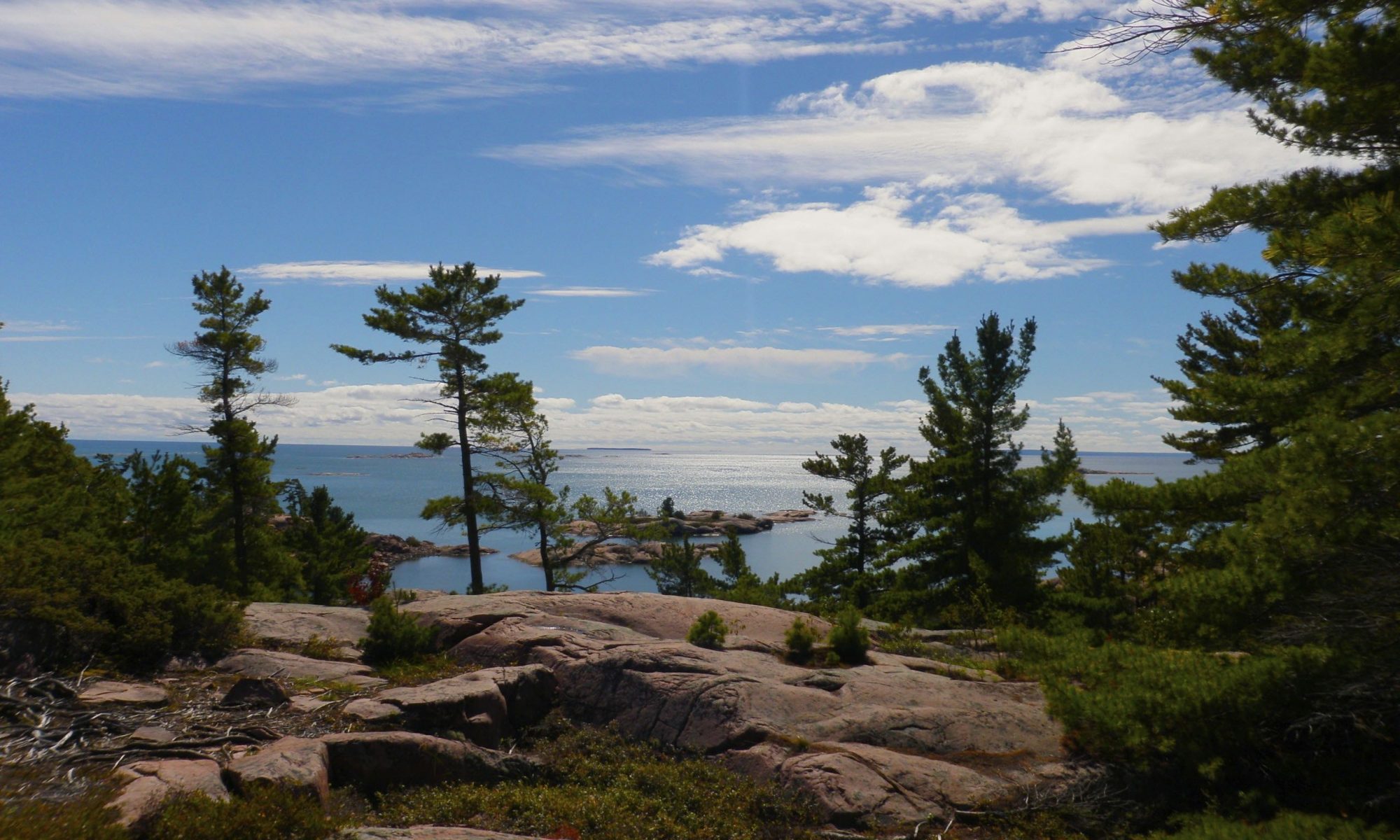
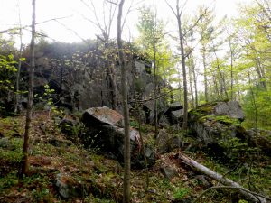
The wilderness interior of Killarney Provincial Park has a very complex geology where granite ridges collide with dramatic white quartzite mountains. The south edge of the park where it is bounded by Georgian Bay is home to another intersection of rock types. Here the pink granite meets the even redder gneiss that originally helped form the LaCloche Mountains.
This area is as distinctive, unique, and beautiful as the park interior. The Chikanshing Trail is short and rugged but very scenic. It follows the creek of the same name out to Georgian Bay and then loops back further inland. The path along the water is by far the most scenic. The creek is the put in point for kayakers and canoeists wanting to circumnavigate Phillip Edward Island. We met a group of anglers returning from a multi day kayak trip when we hiked the trail.
The trail is well marked, though most of the blazes are painted on the rocks so winter travel might be difficult. In some places the blazes can be hard to spot but the trail is still easy to follow. There are also informational plaques that detail the natural, geologic and historic significance of several sights on the trail. The plaques are relatively unobtrusive but they do stand out as unnatural.
The trail isn’t long at all, nor is it particularly difficult, but there is some scrambling required in places. The rocks are twisted into complex shapes that are a strong contrast with the smooth quartzite in the park interior. Windswept trees cling to the convoluted rocks of the trail, and the view of the small islands in the bay formed by the convoluted shoreline is spectacular.
The only downside is the crowds that are attracted by the easy hike and spectacular views. Even in mid September we saw many people on the trail and the water. I can only imagine that it would be worse in the high season.
Tips
The terrain is moderately difficult with lots of ups and down. It’s more interesting than just a straightforward walk.
The scenery is a high point. This is a very beautiful hike.
Due to the ease of access and the proximity to the road this is a very popular hike and there can be a lot of people on the trail.
I’ve wanted to make a trip up Silver Peak for over seven years, but I just never seemed to be able organize it. Part of the problem is that Silver Peak is most easily accessed from the lowlands beyond the northern LaCloche range, and when planning an overnight canoe trip I favour the more rugged landscape in the heart of the LaCloche Hills. It is possible to access Silver Peak as a day trip, but even when camped nearby at George Lake it is best to get up fairly early and I’m not much of a morning person.
I finally decided to try to squeeze an ascent into a very brief weekend camping trip that wouldn’t consume any vacation days but that would also put me close enough to allow for a more relaxed morning. I was a bit slow to organize such an adventure however, so fortunately some of my co-workers ran with the idea when they heard me talking about it. Not only did they get a bunch of people organized and book the campsite, they did take the day off so that they could arrive early and pick up the permit. The rest of us didn’t get to the end of the access road until after midnight.
After unloading the canoes and gear we had a very short paddle in the dark to our campsite. The thick clouds blocked the moon, but it was still light enough to make out the tendrils of mist that clung to the hills of Bell Lake which had an eerie stillness following the rain. It was a surprisingly hot and muggy night which offset the chill that often comes with a heavy downpour. We took advantage of the warmth to shake off the long drive while talking around the campfire late into the night.
While the weather wasn’t great, we really did luck out. There was some torrential rain while we drove up highway 400, but it stopped not long before we arrived at the access point. In fact we managed to avoid the rain all weekend. When we returned to our site on Saturday after visiting the peak our tents and tarp were soaked from what had been a significant downpour even though we’d only encountered a light mist on our way down the mountain.
One of the reasons I’ve been reluctant to plan a backcountry trip in the area is that motorboats are allowed on both Bell and David lakes. David Lake isn’t really an interior lake since it is the access point, but when sleeping in a tent it is nice to feel like you’re alone in the wilderness. Unfortunately we were woken in the morning by two groups of fisherman in aluminum boats who anchored right next to our site.
Silver Peak Hike
Silver Peak, visible from Bell Lake.
We paddled across Bell Lake and left our canoes at the take out for the Silver Peak trail. There are many ways to climb Silver Peak without bushwhacking even though there’s only one official trail to the top. I’d decided to take a slightly longer walk rather than portaging the canoes to David Lake. The trail from Bell Lake to the base of the mountain is an old logging road and makes for very easy walking.
Once we got to the trail for the peak itself things became more difficult. The trail has several steep sections, and several that are quite rocky requiring careful foot placement. In spring it must get pretty wet, but right now the creeks that cross the trail aren’t running very strong. The trail only offers tantalizing glimpses of the view until very close to the top. At one point while only a few hundred meters from the peak I checked our elevation and was surprised to realize that we’d only gone about half of the vertical distance even though we were almost three quarters of the horizontal!
This small stream crosses the trail a few times on the way to the peak.
Where the trail crosses the creek there's some tricky terrain if you want to keep your feet dry.
This little waterfall didn't have much water at this time of year but it was still a pretty diversion along the trail.
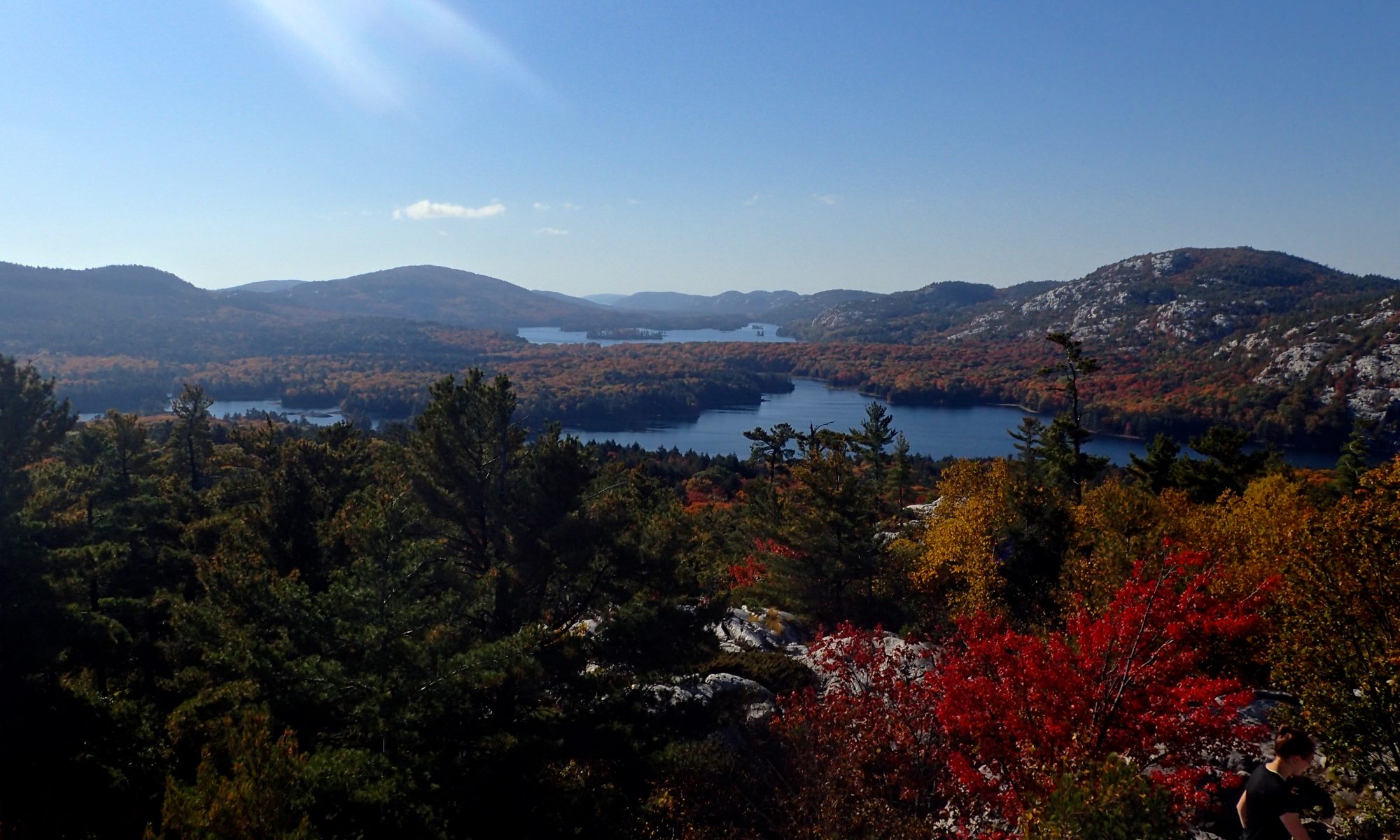
The sun did make a brief appearance just as we neared the peak, but there was a thick blanket of grey clouds covering the sky. Even with the cloud cover the view was spectacular. The sun managed to angle under the clouds and shine off the distant waters of Georgian Bay which provided a spectacular backdrop for the Southern LaCloche hills. This interesting play of the light seemed like a fortunate occurrence just when we arrived but I suspect that there’s always something interesting to see from this vantage point. Below us I could see many of the places I’ve visited in Killarney over the years, and far to the north the Superstack in Copper Cliff marked Sudbury where I grew up. Peeking around the second peek I could see the northern LaCloche hills around Grace and Nellie Lakes that I climbed in August.
Looking north from the first lookout.
The only remains of the fire tower that once stood on Silver Peak are four concrete piers.
It turns out that the highest point of elevation is the further peak.
Killarney Lake and George Lake are visible between the hills.
Looking north from the first lookout.
The only remains of the fire tower that once stood on Silver Peak are four concrete piers.
It turns out that the highest point of elevation is the further peak.
After taking some pictures for a while we returned down the hill and followed the trail back to our canoes. Despite a late start we managed to get back to our campsite in good time and had a bit of light left to prepare dinner. The clouds finally parted after the sun set and we were able to see a spectacular view of the nearly full moon over Bell Lake.
It got cold overnight, and remained so the next morning, but that didn’t prevent Fraser from entertaining us all by jumping in the lake for a frigid swim while we ate breakfast. Without having to hurry we were able to break camp and make it back to the cars by early afternoon to make the drive home.
One of the three people in this canoe isn't pulling her weight.
Cooking banana boats in the campfire after dark.
Mike isn't a bear, but when the stone for the bear bag got caught in the tree he climbed up to liberate the rope.
As cold as it was at night, it was almost colder the next morning, but that didn't stop Fraser from going in for a quick swim.
It was cold at night, and the fire was used for more than just a conversation piece and cooking.
The cloud cover broke on our second night giving us a view of the nearly full moon.
My next destination was the rapids where McCrae Lake dumps into Georgian Bay. This is a much easier destination for a paddle than a hike, but it was a nice day on the trail. Once I left the crowds at the cliff I didn’t see anyone else until I got to the rapids. I was moving pretty quickly so as not to give the bugs a chance to find me, but I did take a break to enjoy the view and catch my breath at the heron rookery. I was worried that I’d scared her away from her nest, so I was glad to see that she was back when I returned.
Shoulda Brought The Focus…
After two weeks of rain we finally had a nice weekend forecast. I had been planning to go camping, but those plans fell through when my paddling partner bailed on me. There were two new caches at McCrae Lake that were still unfound so I had a new destination for a hike instead of a paddle. But the new caches weren’t really my target. There’s a cache nearby on Bears Head Lake that’s pretty much in the middle of nowhere. There was no obvious way to get there other than to bushwhack through the woods.
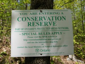
Conservation Reserve
McCrae Lake is always popular, and the sunny weather had brought out droves of people. Parking my car in the only tight spot I could find was almost harder than the first part of my hike.
The Trail
There’s a hiking trail around McCrae Lake that leads to the cliffs at the west end of the lake. The cliffs are a popular destination for climbers and were where the first cache “It’s A Cliffhanger” was hidden. I met lots of climbers at the clifftop. When I finally stopped enjoying the view, found the cache, and opened the log I discovered that I’d missed the FTF by just over an hour! The trail was indeed crawling with geocachers.
Lood down, way down.
When I paddled McCrae last summer I didn't make it down to this end. I'd read about the cliffs and wanted to see them, so this was a great chance.
My next destination was the rapids where McCrae Lake dumps into Georgian Bay. This is a much easier destination for a paddle than a hike, but it was a nice day on the trail. Once I left the crowds at the cliff I didn’t see anyone else until I got to the rapids. I was moving pretty quickly so as not to give the bugs a chance to find me, but I did take a break to enjoy the view and catch my breath at the heron rookery. I was worried that I’d scared her away from her nest, so I was glad to see that she was back when I returned.
The heron took off as soon as I was in view both times I passed the rookery.
There’s an art to a good carin. This one looks like a finger pointing the way.
The trail is sparsely marked in places. I actually prefer that to an over marked trail, but I did lose it a few times as I got near the next new cache, “Chuck And Kevin Get A Little Erratic”. Once I almost wandered into a campers back yard. Whoops. When I finally found the cache I saw that I was just half an hour behind a different cacher on this one, and another group was just fifteen minutes behind me!
I lost the trail again and ended up bushwhacking to the rapids. I walked right past the large cross on the hill, and had an interesting descent. I stopped on the rocks overlooking the rapids to cook myself a burger for lunch. In retrospect bringing the stove and burgers for lunch was probably overkill, but it did make for a hearty snack before attempting my destination cache for the day, “Bears Head”.
Normally I travel very light. Today I brought everything including the kitchen sink. In retrospect the second burger was a mistake. I wasn't hungry once all day.
Two patties? What was I thinking!
The Bushwhack
Since I was going to be bushwhacking I needed to do some planning before I set out. I didn’t have a trail map so I didn’t know exactly where the hiking trail was, but by studying the satellite photos before I set out I was able to design a trail that I thought would connect with it. My biggest worry was getting trapped behind a marsh or bog that would be too difficult to cross, so I drew a line on the map that followed the rocky outcrops as much as possible. I also downloaded the satellite photos to my Oregon so I could see where I was as I walked in case I ran into some difficulties.
After all that planning I almost didn’t make the attempt. When I got to my lunch spot I examined my track and saw where the trail would cross my planned bushwhack. The distance would be about 2 kms one way, as the crow flies, and it was getting late in the day. I decided that if I could get to the start of the bushwhack by 5:30 I’d make the attempt.
I got there with 5 minutes to spare, so I decided to go for it. The vegetation is fairly sparse, and I was able to make reasonable progress. It was a little tricky to stick to the line that I’d drawn on the map, and following the contours of the land was quite exhausting because there was much more up and down than on the marked trail. I knew my plan was working when I got to one of the turns in my planned track and saw that I had just avoided a large bog.
It wasn’t all roses however. I was 340m from the cache when I came to a wet soggy area that I had to cross. Despite some hummock hoping I got double soakers. Still, it was a lot better than crossing the marsh right next to the lake. I don’t know if it’s a common occurrence, or a result of all the recent rain, but the marsh is overflowing into the lake and washing a swath of vegetation off the rocks between the two.
Rocks
As soon as I stopped moving the skeeters swarmed me, and I had to look for the cache quickly. Fortunately it was a very easy find. Bears Head lake is quite pretty, but the bugs and the time of day mean that I signed the log quickly and ran. I was quite surprised to see two parallel tracks worn into the moss on the rocks near the cache. Obviously there’s a way to get an ATV in here, and it was quite surprising to find out that this was a ‘roadside’ cache. The only other things that broke the spell of being isolated in the bush were the sounds of boats nearby on Georgian Bay, and a lone piece of flagging tape I spotted while deep in the bush.
Getting back to the trail was a little easier than getting to the cache. In the end it was a 5k bushwhack and took an hour and forty minutes. After that it took another hour and a half walking on the trail to make it back to my car just 15 minutes before sunset. I stopped at the top of the cliff on my way out to catch my breath and enjoy the view.
Bearshead Lake
Tips
Like my other trips to McCrae Lake my geocaching may have led me astray. The bushwhack to the cache was the least scenic and most difficult part of my trip. So unless you intend to find the cache I wouldn’t recommend it. But I’m still pretty glad that I went :-). If you want to camp at McCrae Lake you’ll find it far easier to canoe in than to hike, but hiking is a possibility as there are a few campsites not far from the trail.
Mashkinonje Provincial Park is officially a non operating park, but thanks to The Friends Of Mashkinonje it still has a lot to offer. In fact, part of the parks appeal is that it is less developed (and I assume less travelled) than larger more active parks. I didn’t even know about the Mashkinonje until a few days ago when I was looking for a wilderness geocache to find in the Nipissing area. While not as famous as parks such as Killarney, Algonquin and Killbear the Mashkinonje offers a subtle less crowded experience.
I visited Mashkinonje twice in late December because on the first day I ran out of time. The snow level was such that walking was a bit tiring, but not so deep that I wished for the discomfort of snowshoes. A few more inches of snow however and I would have wanted some help to float over it.
There’s an extensive network of trails in the park. They’re all very well marked with clear and obvious blazes. With very few exceptions I was able to find the blazes and easily determine the direction they were indicating. In addition to the blazes there are clear and obvious signposts at all of the trail intersections, and excellent maps. The maps are very high quality topographic maps and include trail names and points of interest. Combined with the signs and junction markers they make it very easy to navigate the park trails. In addition to the blazes there are extensive boardwalks in low lying swampy or marshy areas (of which there are many). I can only assume that the bugs are horrendous at certain times of the year.
This may seem like a lot of infrastructure but despite this the park still feels very unspoiled. The trails are narrow tracks through the brush and many of them wind their way amongst the rocks and trees in a very natural way with plenty of interesting elevation changes. It certainly doesn’t feel like walking down a logging road, rail trail or snowmobile trail. When I reached Warren Bay I expected to see the far shore (that is outside of the park) dotted with cottages but it was clean as well. The ice had some animal tracks but it wasn’t until the channel had narrowed considerably that I saw any skidoo tracks. This all conspires to make the park feel very remote and wild.
When I visited I had to break fresh trail through the snow because there had been no recent visitors. Often wildlife tends to shy away from trails because of the traffic, but the trails here were crisscrossed with the tracks of many different animals. In several areas the tracks followed the trail for several hundred meters as if the deer were reading the blazes. I saw many deer and hare tracks, as well as several different types of bird. In one spot on the remote Atakas trail I found an area where a deer had recently laid down in the snow. I also encountered two sets of tracks that had foot pads instead of cloven hoofs, and appeared to belong to a wolf or a coyote. There was also one set of tracks that an overactive imagination could imagine belonged to a bear, but were more likely caused by a much smaller animal hopping through the snow.
Despite all of the tracks the only animal that I encountered was a woodpecker hammering away at a tree where the Coastal and Atakas trails meet. I heard a distant howl in the daytime, and a similarly distant barking after the sun had set. Wilderness in the winter always feels a little desolate, and this was no exception.
This map is posted just a few meters past the Samoset trailhead. It's an overview of the whole park.
These detail maps are posted at all of the trail intersections.
Took the same picture on different days.
One of the many bogs the trail circumvents.
This map is posted just a few meters past the Samoset trailhead. It's an overview of the whole park.
These detail maps are posted at all of the trail intersections.
Took the same picture on different days.
One of the many bogs the trail circumvents.
This map is posted just a few meters past the Samoset trailhead. It's an overview of the whole park.
Samoset Trail
The Samoset trail starts at the Blandings Access point. It is a relatively easy hike with few elevation changes, but there are a few areas that cross some rock outcrops. The first of these around point 12 on the map has a bench and is where the Samoset trail loops back on itself, so make sure you select the correct path when leaving the clearing. One of the trails is a bit hard to find.
Lapin Beach Trail
The Lapin Beach Trail is a short loop and one of the few trails that I hiked in it’s entirety. Lapin Beach is one of the water access points for the park and is identified with a historical marker on the map. I wasn’t able to find out what the marker referred to and didn’t see any structures at the location indicated on the map so it’s a bit of a mystery to me.
The trail is bordered by bog and marshlands on two sides, Lake Nipissing on another, and runs through the woods on the last. The trail is mostly flat and quite easy, but I did see a sign warning of poison ivy in the summer, and finding the markers on the southern section was a bit tricky after dusk (but would probably be quite easy in daylight).
Coastal Trail
The Coastal Trail follows the shore of Lake Nipissing and climbs up and down the rocks along the shore. The elevation changes make the trail a little more challenging than the Samoset trail especially if you’re trying to keep ahead of a setting sun. There are several lookouts scattered along the trail with rustic benches. I only hiked as far as the bridge where the Coastal Trail joins the Atakas trail but the Coastal Trail continues almost to the north border of the park. The Coastal Trail is the most scenic part of the park that I visited.
Atakas Trail
After finding my geocache I decide to return partway via the Atakas trail for some variety. The Atakas (Cranberry) trail runs inland along the edge of a large bog. One section of trail has steel signs on posts rather than blazes on trees and appeared to be in the water rather than on the rocks. I’m not sure how nasty this stretch would be in the summer when there is no ice. As it is I was careful to avoid breaking through the thin ice, and other than some ominous sounds had no problems.
Following this there are many small hills to climb and this was the most challenging section of trail on my hike. I encountered a downed tree that required some clambering to circumvent and some of the blazes were harder to find than elsewhere or were pointing in odd directions.
Beckett Lang Trail
The Beckett Lang Trail is a very short trail that connects the Coastal Trail and the Atakas Trail where they are close to each other. It isn’t difficult at all.
Gibson River Provincial Park is another one of Ontario’s minimalist parks. It’s classified as a nature preserve and offer’s few facilities other than a parking lot. The Five Winds Backcountry Ski Club maintains a trail network throughout the park and beyond, and thanks to the lack of snow this winter it was possible for us to hike the trails without skis or snowshoes in January. The recent freeze/thaw cycles made for some hidden ice in spots, and the warm temperatures meant that the ice wasn’t safe to walk on anywhere, but for the most part the conditions were ideal for hiking.
I wasn’t able to find a map of the trails prior to our trip, but the Five Winds club does make a map available to their members. I believe that I met one of the members last fall as he was marking the trails from the Nine Mile Lake access point, and he showed me his map then. The trails are quite extensive and I wouldn’t consider my GPS track log representative of the network at all. Furthermore there are areas where the blazes are difficult to follow and we did bushwhack a couple of times during the course of our trip so there are a few sections that aren’t the right way to go.
I had heard reports from other hikers that the trails were at times difficult to follow, and we did have some difficulty identifying blazes in a few locations, but for the most part it was easier than I expected to stay on the marked trail. We were assisted by the trail of geocaches that I was finding (or rather not finding). We had to cross a few boggy areas but none of the trails took us over the dangerous deeper water. We crossed one beaver dam in the smaller hydro corridor, and we went through thin ice several times, once in a bog, but more frequently in puddles collected in the low points of the trail.
The terrain we traversed is similar to the nearby McCrae Lake Conservation Trail, but it has a different character. A lot of the area we traversed was swampy and boggy, but there was one section with nice granite ridge tops that were littered with light grey erratics. I would say that the trail closer to the Bay is a bit more scenic but it’s very hard to compare with a trail that I’ve only hiked in the summer.
The high point of our hike was the visit to Long Falls. Long Falls are located outside of the park along the Gibson River. The river was running quite quickly and the falls were very scenic. We followed our intended trail to the falls but we took an ATV trail on the way out that we discovered when we had made a wrong turn earlier in the day. The snow covered most of the scars left by the ATVs except for a few large puddles where the quads had really bogged out. It wasn’t quite as demanding as the way we went in, but by that time of day I don’t think any of us minded [:)].
Tips
Gibson River Provinical Park is quite remote with very little infrastructure so it is a destination if you’re looking for a wilderness experience. That said there are a few things that take away from the feeling of remoteness.
There is a large hydro corridor adjacent to the park, and an extensive set of OFSC snowmobile trails run through this area. The hydro corridor is quite barren visually and the trails must have quite a bit of traffic at times. We heard a few sleds, but didn’t see any.
There is a smaller hydro corridor that runs through the park.
There’s at least one ATV trail that runs through the park itself (in flagrant disregard for the parks nature preserve status). In summer this trail is probably pretty unsightly with deep ruts cut where quads get stuck.
Other considerations when visiting the area:
Large areas of the park are quite boggy and marshy so expect to donate a few litres of blood to flying parasites if you visit in the spring.
No camping is allowed within the park itself, but it is allowed on the adjacent crown land. There are portages along the Gibson River around the rapids. That said I hear that the river is a difficult trip when water levels are low.
This was a short hike that I took on my way back from camping at Cyprus. I chose the area because I was looking for an interesting Geocache and a good hike to close out the weekend. Unfortunately I DNFd both caches in the area: ”Lions Head Lookout” and The Trial Series #3” but the hike and views were both more than worth the trip. I only explored a small fraction of the trails in the area which criss-cross the Lion’s Head Provincial Nature Reserve but the small area that I did see was so stunning that I’d like to come back to see the rest.
I had seen the cliffs at Lion Head before, and thought that a hike would be nice but wouldn’t afford great views since I’d be standing on the most interesting thing to look at, but I learned how wrong I was.
The trailhead parking is fortunately halfway up the cliff, and starts out by sharing a private road. The first half kilometre is quite plain, but the trail becomes steeper at first, and then increasingly rugged until it is quite challenging. It is always quite clearly marked, but there is a lot of very convoluted rock to cross making for a rewarding hike.
There are two significant potholes on the side of the trail, one that broke through the rocks at the bottom to create a vertical chimney. Standing at the bottom and looking up at the tiny hole at the top is an interesting sight. A series of 3 more large potholes dot the rock ledge near the first lookout , and several potholes of various sizes can be seen bisected by the edge of the cliffs.
The first lookout is recessed and affords an impressive view of the bay, the shore below, and the walls of the cliff to either side. As the trail continues it seems that each successive lookout is more impressive than the last. Each one juts out a little further from the cliff face, affording a better view of the cliffs behind.
After a weekend of exploring the escarpment I was actually starting to feel overwhelmed by the relentlessly stunning scenery. I snapped a lot of pictures at first, but by the time I reached the final lookout I had given up, realizing that the pictures would not do the view justice. The trail continues around the tip of the isthmus, but it came to an end for me at a lookout that hangs out from the face of the cliff far enough to afford dizzying views of the cliff faces in both directions. With the sun low in the sky and sparkling on the water the overall effect was overpowering. There was almost no direction I could look without seeing something amazing. The only time that I have seen such an overpowering view was after climbing Mount Caroline Livermore on Angel Island in San Fransisco Bay.
I must admit that I did the area disservice by turning around when I did, but I was already late and had to head back, but I will return. This is an area that can only be properly experienced directly – no pictures or description will do justice to the impact of the scenery.
I camped at Cyprus when I was a young boy. I remember asking my parents why we were going on a hike – not something we typically did while camping. They told me that there would be caves and that we’d have to watch out for rattlesnakes, which made it seem exotic.
I was disappointed that we never saw a rattler — it turns out they’re quite shy. I was also disappointed that the caves weren’t dry and deep the way they were in movies, but I was also struck by the beauty of the landscape along the coast and have remembered it all these years.
I tried to return with my family about eight years ago on the way back from a trip to Manitoulin, but the park was full and we slept elsewhere. We ended up exploring Cabot Head instead of the Cyprus Lake area. In the intervening years I’ve never been organized enough to book a site in the summer because of the long wait times. This time we planned ahead and booked the first weekend after the summer season.
A week before the trip my wife broke her toe, making hiking a less than comfortable prospect. We almost cancelled the trip, but in the end I decided to come alone.
The bridge on the Georgian Bay Trail is currently under construction and officially closed, but is still very easy to cross. I took the Georgian Bay Trail to the cliffs so that I could visit the sinkholes, and took the Horse Lake Trail on the way back. Both trails are very easy until you reach the bay where the terrain becomes more rugged.
I still didn’t see a rattler, but there was a garter snake sunning himself in the sinkholes and I think I heard a rattle on the boardwalk on the return trail where others had reported seeing a snake.
The features at Indian Cove and the grotto were as spectacular as I remembered. The only surprise was the number of people. My memory (perhaps inaccurate) was that we only encountered the odd hiker, but this time the cove and grotto were crowded with people dressed more for a beach than for a hike.
When I was a boy my parents wouldn’t let me attempt the more adventurous climbing that I saw some of the hikers doing. It was great to return as an adult, since now I was ‘responsible’ and able to decide where I could and couldn’t climb. The cliffs are incredibly easy to climb, and I was able to visit all kinds of neat nooks and crannies. I remembered one of the more impressive caves from when I was a boy, and it is now a virtual cache. I did choose to heed the signs at the trailhead and not practice cliff diving, but there were several people who did.
It would be fitting if this spot were more isolated, the reward near the end of a long hike along the Bruce trail, so that it could be enjoyed quietly. But it’s hard to begrudge the crowds (myself included) the opportunity to easily enjoy such a spectacular spot.
It was really cold, so I didn’t venture in, but this brave soul dove down to explore the underwater tunnel.
Light from Georgian Bay streams through the underwater tunnel.
After exploring the area I continued west along the Bruce trail. There are some spectacular views from the cliffs, and some dangerously precarious looking overhangs. There were still a fair number of people on the trail, so I kept hiking until I couldn’t see anyone, around Loon Lake. I would have liked to continue, and kept saying “just a bit further” to myself but I eventually had to turn back. I followed the coast to the East of the cove which is another spectacular spot. Despite being late in the day there were still quite a few people coming along the base of the cliff from Horse Lake Trail.
While the cliffs at Cyprus aren’t the tallest on the escarpment, they are some of the most beautiful. The water is an amazing shade of blue, and the access is easy enough that this is a very attainable family outing. I was pleased to see many children creating memories that will last a lifetime, telling their parents what an amazing place this was. Truly one of the jewels of Ontario.
The storm intensified through the night and I had my first opportunity to enjoy a thunderstorm while sleeping in a hammock. The lightning was about ten seconds away, but that’s enough to make quite a bit of noise and light up the sky dramatically. I had set my hammock up with the fly a bit high and I was worried that water was dripping onto my feet. A bit was splashing on the ground and then up under the tarp, but most of what I was feeling was the drops of water vibrating the tie out lines for the hammock. It was a cold night and I didn’t want to risk getting my sleeping bag wet so I experimented with putting my feet up on the high side of the hammock, but that was too uncomfortable. I was starting to be jealous of Alex in his tent, but when he got up the next morning I found out that he was even more wet thanks to a leaky fly.
Normally I read quite a bit while camping, but we’d been staying up pretty late and I’d been sleeping uncharacteristically well, so this was the first night of the trip that I did much reading. I eventually drifted off to sleep, but was woken by thunderbolts several times.
We didn’t see much sun while on Grace Lake, but it did poke through one morning as it rose.
The rain seemed to have stopped by dawn, but the clouds weren’t letting the sun through at all. It sprinkled rain a couple of times while I made pancakes for breakfast, but it did seem to be clearing up by the time we headed out to do some ridge running. There are inviting hills all around Grace Lake, but we decided to visit Carmichael’s Rock first and then see how time and the weather left us.
The climb up to the rock was a bit more difficult than I remembered, particularly with the rocks so wet. I managed to find the rock without having to rely much on my GRSr even though I didn’t have a printout of the photo to guide me this year. (Just like last year I’ve deleted the actual location of the rock from my GPS track logs).
Alex contemplates the same view that Franklin Carmichael did 80 years ago.
The portage from Grace to Nellie runs through the saddle at the east end of the lake.
Looking north we can see the northern boundary lakes that we traversed just a few days ago. It also gives a sense of just how high Grace Lake is up in the mountains.
The view is a bit restricted looking south from this peak, but we could see a dark gray storm cloud coming our way. Within minutes we were drenched.
As we descended the hill we could see the rain sweeping across the lake below.
We climbed to the top of a nearby peak to see the view and decide what to do next. From the peak Grace Lake stands out against the hills even further below, highlighting the fact that it’s perched high up in the hills. When we turned to look south we could see the hills and islands of McGregor Bay receding into the mist below and a dark storm cloud heading our way from above! There was no time to find any shelter better than some trees, and within minutes the storm was upon us, beating down with torrential rain. We tried to wait the rain out but it showed no signs of letting up after a few minutes, and we decided to head downhill when we heard a warning rumble from the sky.
We had to proceed very carefully down the hill on the wet rocks. Normally I’m very diligent about turning the canoe over, but this time I forgot, and when we found it the back end was already full of water. There had been no more thunder so we dumped out the boat and paddled back to our campsite in the torrential rain. By the time we got back to our tarp we were thoroughly soaked and there was no sun to dry out our clothes.
We changed into the driest stuff we had, and then began a long wait for the rain to stop. I had hoped that we could do some more exploring later in the day, but the threat of rain never passed for long enough for us to venture out again, so we just watched the clouds and talked.
Back at our campsite it’s hard to tell the difference between clouds and rain as they sweep through the hills.
Cloud watching on Grace Lake is an interesting experience because at times the hills, and even the lake, are in the clouds. Sometimes the east end of the lake would disappear entirely, and then the large mounds of rock surrounding the lake would slowly begin to reappear, at first as dim shadows which slowly resolved themselves into white hills, until finally we could watch tendrils of fog and mist wrap themselves around the peaks and through the valleys. When the water came down hard the sheets of rain would curl and twist across the landscape.
We did finally get enough of a dry spell to get a fire going, and we were able to emerge from the tarp for long enough to cook dinner in the open, but then the rain came again and put out our fire. We decided to call it a day and go to bed early when Alex was bitten by one of the carpenter ants that were infesting our refuge. I had hoped to read a bit before going to sleep, but as soon as I got settled in my hammock the batteries in my flashlight died, so after a bit of tossing and turning I finally went to sleep.