I’ve wanted to make a trip up Silver Peak for over seven years, but I just never seemed to be able organize it. Part of the problem is that Silver Peak is most easily accessed from the lowlands beyond the northern LaCloche range, and when planning an overnight canoe trip I favour the more rugged landscape in the heart of the LaCloche Hills. It is possible to access Silver Peak as a day trip, but even when camped nearby at George Lake it is best to get up fairly early and I’m not much of a morning person.
I finally decided to try to squeeze an ascent into a very brief weekend camping trip that wouldn’t consume any vacation days but that would also put me close enough to allow for a more relaxed morning. I was a bit slow to organize such an adventure however, so fortunately some of my co-workers ran with the idea when they heard me talking about it. Not only did they get a bunch of people organized and book the campsite, they did take the day off so that they could arrive early and pick up the permit. The rest of us didn’t get to the end of the access road until after midnight.
After unloading the canoes and gear we had a very short paddle in the dark to our campsite. The thick clouds blocked the moon, but it was still light enough to make out the tendrils of mist that clung to the hills of Bell Lake which had an eerie stillness following the rain. It was a surprisingly hot and muggy night which offset the chill that often comes with a heavy downpour. We took advantage of the warmth to shake off the long drive while talking around the campfire late into the night.
While the weather wasn’t great, we really did luck out. There was some torrential rain while we drove up highway 400, but it stopped not long before we arrived at the access point. In fact we managed to avoid the rain all weekend. When we returned to our site on Saturday after visiting the peak our tents and tarp were soaked from what had been a significant downpour even though we’d only encountered a light mist on our way down the mountain.
One of the reasons I’ve been reluctant to plan a backcountry trip in the area is that motorboats are allowed on both Bell and David lakes. David Lake isn’t really an interior lake since it is the access point, but when sleeping in a tent it is nice to feel like you’re alone in the wilderness. Unfortunately we were woken in the morning by two groups of fisherman in aluminum boats who anchored right next to our site.
Silver Peak Hike
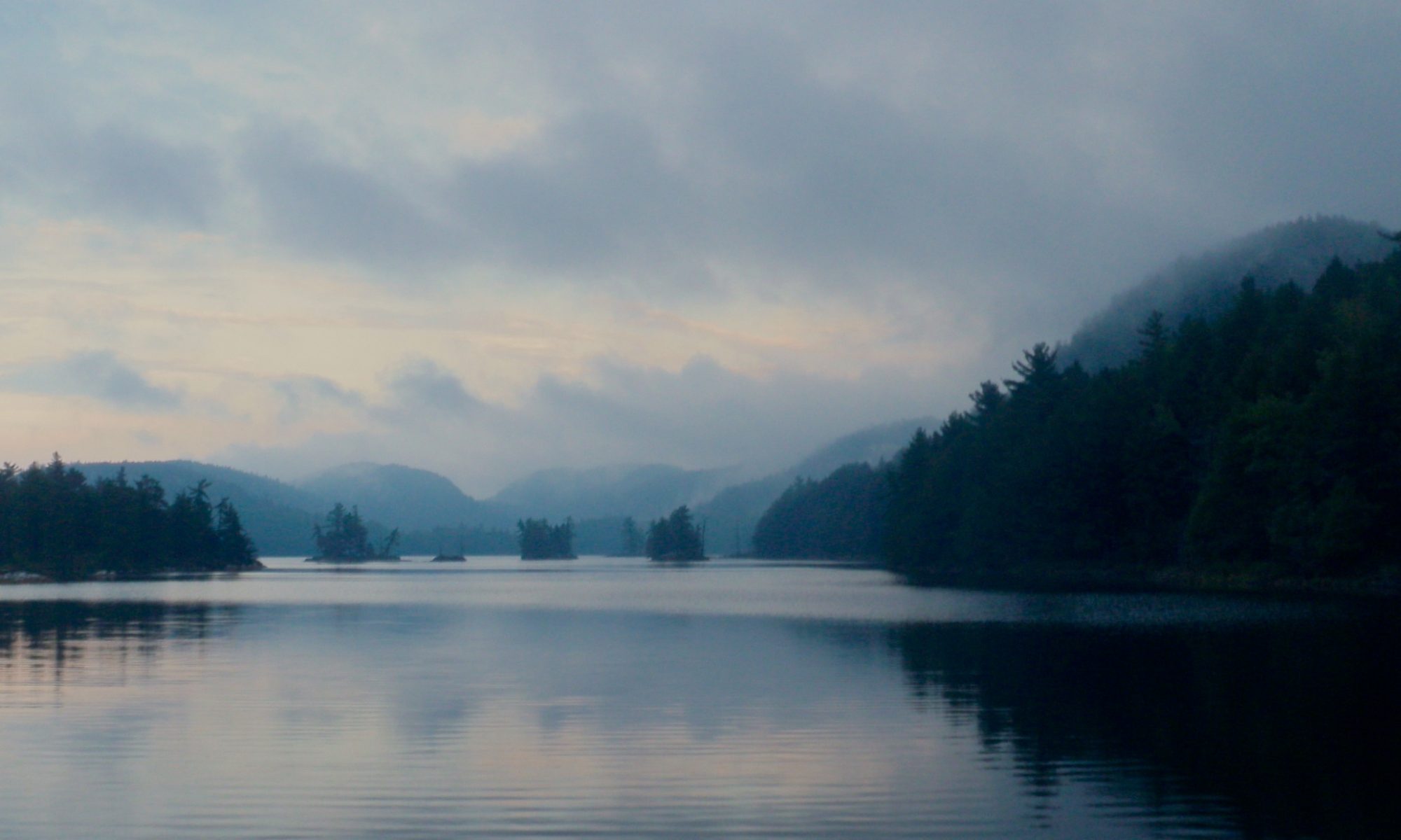
Silver Peak, visible from Bell Lake.
We paddled across Bell Lake and left our canoes at the take out for the Silver Peak trail. There are many ways to climb Silver Peak without bushwhacking even though there’s only one official trail to the top. I’d decided to take a slightly longer walk rather than portaging the canoes to David Lake. The trail from Bell Lake to the base of the mountain is an old logging road and makes for very easy walking.
Once we got to the trail for the peak itself things became more difficult. The trail has several steep sections, and several that are quite rocky requiring careful foot placement. In spring it must get pretty wet, but right now the creeks that cross the trail aren’t running very strong. The trail only offers tantalizing glimpses of the view until very close to the top. At one point while only a few hundred meters from the peak I checked our elevation and was surprised to realize that we’d only gone about half of the vertical distance even though we were almost three quarters of the horizontal!
This small stream crosses the trail a few times on the way to the peak.
Where the trail crosses the creek there's some tricky terrain if you want to keep your feet dry.
This little waterfall didn't have much water at this time of year but it was still a pretty diversion along the trail.
The sun did make a brief appearance just as we neared the peak, but there was a thick blanket of grey clouds covering the sky. Even with the cloud cover the view was spectacular. The sun managed to angle under the clouds and shine off the distant waters of Georgian Bay which provided a spectacular backdrop for the Southern LaCloche hills. This interesting play of the light seemed like a fortunate occurrence just when we arrived but I suspect that there’s always something interesting to see from this vantage point. Below us I could see many of the places I’ve visited in Killarney over the years, and far to the north the Superstack in Copper Cliff marked Sudbury where I grew up. Peeking around the second peek I could see the northern LaCloche hills around Grace and Nellie Lakes that I climbed in August.
Looking north from the first lookout.
The only remains of the fire tower that once stood on Silver Peak are four concrete piers.
It turns out that the highest point of elevation is the further peak.
Killarney Lake and George Lake are visible between the hills.
Looking north from the first lookout.
The only remains of the fire tower that once stood on Silver Peak are four concrete piers.
It turns out that the highest point of elevation is the further peak.
After taking some pictures for a while we returned down the hill and followed the trail back to our canoes. Despite a late start we managed to get back to our campsite in good time and had a bit of light left to prepare dinner. The clouds finally parted after the sun set and we were able to see a spectacular view of the nearly full moon over Bell Lake.
It got cold overnight, and remained so the next morning, but that didn’t prevent Fraser from entertaining us all by jumping in the lake for a frigid swim while we ate breakfast. Without having to hurry we were able to break camp and make it back to the cars by early afternoon to make the drive home.
One of the three people in this canoe isn't pulling her weight.
Cooking banana boats in the campfire after dark.
Mike isn't a bear, but when the stone for the bear bag got caught in the tree he climbed up to liberate the rope.
As cold as it was at night, it was almost colder the next morning, but that didn't stop Fraser from going in for a quick swim.
It was cold at night, and the fire was used for more than just a conversation piece and cooking.
The cloud cover broke on our second night giving us a view of the nearly full moon.
Muskoka is known for rugged beauty, but not particularly for unspoiled wilderness. There are a few lakes whose shores aren’t encrusted with cottages and constantly patrolled by buzzing motorboats however. One of the largest such areas is along the course of the Gibson River.
I invited some co-workers to come for a late September canoe trip in order to find some Geocaches. Planning isn’t my strong suit, and late September turned into mid October before we headed out.
There were four of us, and the usual complexities coordinating a group of people landed us on a date with a less than stellar weather forecast, calling for 10 – 20mm of rain. Hours before our departure Environment Canada posted an extreme weather advisory calling for 45 – 50mm of rain. Oddly enough the forecast continued to predict only 10 – 20mm. The temperature was warm, the winds low, and the plans made, so we decided to press on despite the alert. The rain proved annoying, but not extreme.
I thought that the rain would mean that we were the only paddlers on the water, but we saw a lone kayaker putting in at the marina and we encountered a large group of 10 – 12 canoes paddling out on Nine Mile Lake. They had been camping on Turtle Lake since Friday night. They must have had a very cold and wet trip. Nine Mile Lake was the only part of our trip where we saw cottages, and the portage to Turtle Lake is just around the bend from the last of the houses. Once we got off of Nine Mile Lake we were completely alone, and the only sound of civilization was a train (the tracks cut right through the area we were paddling, but we didn’t make it far enough to see them). There were some boats stashed at the end of the Turtle Lake portage, but other than the blazed trails themselves and the occasional campsite the illusion of being deep in the backcountry was perfect.
The portage was a bit wet. In fact there was a waterfall right down the middle of the trail! The portage only went as far as the marsh on the maps, and I’d hoped we’d be able to paddle the bulk of it, but the marsh was far too dry so we had to do a 500m carry. There were several large (and cold) puddles on the trail that could be avoided with some extra effort, but I was already so wet I finally just decided to walk through them. Other than the water the portage was quite easy, but the trail isn’t as wide and worn as one you’d find in a large well maintained park like Killarney.
All of the lakes were well sheltered from the wind, if not the rain, and the paddle down Turtle Lake was easy. Turtle Lake is a good example of Canadian shield terrain, but not particularly remarkable in any way until you reach the south end. There it hooks West as it funnels between rock faces on both sides. There are a lot of standing dead trees in the water here, but the water is quite deep so it’s fairly easy to paddle between them. It’s a scenic little channel. There were a couple of places where I wasn’t sure where to turn, but we found the right path without much difficulty.
The beaver dam at the end of the channel isn’t particularly long, but it’s height is quite impressive. It’s constructed as a pair of arches braced against a small rock island in the middle to hold back the large volume of water.. The water on the upstream side of the dam is quite deep and was noticeably colder than in other parts of the lake. There must be several generations of beaver families who’ve worked on this dam. Unfortunately I didn’t manage to get a picture that shows off the height of the structure.
The remaining distance to Brotherson’s Lake is a short 200m portage, but just like the water it drops quite abruptly at the end. The shore of Brotherson’s Lake is ringed by small cliffs because it’s so much lower than the surrounding terrain. It makes the lake a little more scenic than Turtle Lake on the other side of the hill.
After a short paddle on Brotherson’s Lake we came to the channel that connects it to Narrow Lake. The channel was navigable without having to line the canoe, but just. Most of the channel is a mud flat covered by a few inches of water, but the current has carved a deeper passage that winds through the middle. The deeper channel is actually visible on the Bing Maps satellite photos (a cloud obscures the channel with the current Google Maps imagery). On our way into Narrow Lake it was pretty easy to see the deeper channel from the stern, but on the way out the rain had started again and covered the surface of the water with ripples which made navigation more difficult.
Our final destination was Narrow Lake, and we were only out for a day trip, so once there we turned around and headed back. We switched up the portaging duties on the way out, and also let some of the other members in our group try paddling from the stern. We made it back to the marina just after dark, but we had cleared all of the portages by the time the sun set.
Tips
There’s pay parking and free parking at the marina. Your choice pending availability.
Other than the remoteness this is a fairly easy trip. There are many other trips that can be had in the area, and being a little more wild than a developed park it’s fun to explore. Just make sure that you’re prepared with a good map and leave yourself some extra time since the trails aren’t rigorously maintained.
If you intend to camp we did see several posted sites with fire pits but I have no idea if they also have thunder boxes, or if they are maintained at all. Of greater importance I have no idea how busy they get, so I don’t know how hard it would be to find a site in high season.
Much of the early history of Algonquin Park has its roots in Canoe Lake. The lake has long been a focal point for tourism in the park, and many of the historic camps and lodges are located on or near Canoe Lake. There’s even an old mystery. In 1917 Tom Thompson drowned under suspicious circumstances while paddling the lake. Thompson was a renowned painter and served as an early inspiration for the members of the group of seven.
Canoe Lake is also one of the busiest areas in the park, and the shear volume of traffic has led to it’s being referred to as ‘Yonge Street’. The shore of Canoe Lake is encrusted with cottages, and the interior lakes nearby are dotted with so many campsites that it’s rare to not be able to see your neighbours. When I go camping I’m trying to experience nature as unblemished by humans as possible so I decided to visit Canoe Lake early in the season before the crowds made an appearance. I was able to make my reservation just a few days ahead of my trip (something that’s impossible in the high season), but there was still enough traffic that we were never truly alone. It wasn’t as bad as car camping but we met people frequently on the portages and we could hear people both nights while at our campsites.
I also favour a bit of a challenge so rather than just parking ourselves at one of the first interior lakes we decided to complete the Canoe Lake Circuit through Burnt Island Lake, Sunbeam Lake and Tom Thompson Lake. It’s not a difficult trip, nor did it take us very far into the interior, but it gave us a workout and was more interesting than just staying in one place.
Day 1
The parking lot was packed when we arrived, and the portage store and permit office were crowded as well. It was a bit late in the day by the time we had our canoe in the water but we still had plenty of time to reach Burnt Island Lake. Canoe Lake was the least scenic lake of our trip. Not only are there cottages everywhere, but the shore is almost completely devoid of the rugged rocks that add so much to the scenery of the lakes further from the highway. We took note of some of the old camps on the lake as well as the area where Tom Thompson’s body was found, but we proceeded fairly quickly to the first portage.
The portage to Joe Lake is one of the most popular and also one of the easiest in the park. It circumvents the spillway from the dam that forms Joe Lake. There are still a few cottages on Joe Lake, and there was a line of motor boats waiting for us to cross under the rail bridge just after the dam. The scenery is a bit rockier and prettier on Joe Lake and as we pulled away from the dam and the traffic I started to get into the rhythm of the trip.
Joe Lake narrows at the northeast end until it’s just a small creek that winds back and forth. We took a hint from Jeff’s Map and skipped the first portage that only cuts off a short loop of river. I was pretty surprised when we got to the next portage that took us to Baby Joe Lake. The take out was built up with a dock and stairs so elaborate they would have been more at home on the shore of an expensive cottage than on a ‘backcountry’ portage.
There’s a geocache hidden on the portage so I hauled our canoe out of the water and up the stairs to clear the path for other paddlers before propping the canoe against a tree before we started hunting for the cache. I had some trouble finding the cache and when I finally had the log book in hand we were all startled by a large crash behind us. It took me a moment to realize that the canoe had rolled off of the branch where I had balanced it and fallen to the ground. Fortunately it appears to be unharmed, but it sure was loud when it fell!
I'd be proud to have these stairs in my yard, but it's a bit strange to find them here on a portage.
Is this a deck, or a portage?
The last portage of the day done.
We didn’t see any, but the woods were full of ruffled grouse. We could hear the drumming display that the males use to announce their territory and to attract a mate. The drumming is a low booming that starts out slowly and builds in frequency. It’s something that you feel more than hear. I’ve experienced them before, but I always assumed that the sound was a chainsaw or motorboat being started in the distance. This time there were so many we decided it had to be an animal and I looked them up when I got home. To make the sound the male grouse beat their wings so rapidly that it creates a partial vacuum. The air rushing back in echoes with the distinctive booming sound.
After a quick paddle across Baby Joe Lake we arrived at another overbuilt portage. This portage forks in two directions, a short 200m carry to Burnt Island Lake and a more strenuous 1140m carry to Littledoe Lake. To keep paddlers from being confused the wooden chute splits at the end to lead you down one of the two paths. The put in on Burnt Island Lake is heavily overbuilt as well with a short retaining wall maintaining a crisp edge for launching canoes.
We met an interesting group heading in the opposite direction on this portage. It was late in the day and while there are campsites on the Joe Lakes there’s no compelling reason to camp there so I assumed that the group must be heading back to Canoe Lake. I commented on how late they were. One of the group replied that they were indeed late, and had been on the water for 16 hours! They started the day on Catfish Lake and then paddled north to Brent which is at the extreme north end of the park before turning around and heading back to Canoe Lake in the centre of the park. I gather they were doing “The Brent Run” which is a race against the clock to see how fast you can do a trip that is normally done in days instead of hours. It’s not my kind of trip, but good for them!
Burnt Island is a pretty lake but not spectacular. It was the first large lake we travelled that was devoid of cottages and doesn’t allow motor boats so it was closer to an ‘interior’ experience than we’d had thus far. Even without cottages it was somewhat crowded. There are a lot of sites on Burnt Island Lake, but most were occupied. We were heading for a nice looking site on a point when we spied a canoe behind the trees. After searching some more we started to unload on a promising looking island site before we noticed a food bag hanging high overhead. It was now late enough that we decided to stop being picky and take the next available site we found.
We ended up with an uninspiring site on the west shore of the lake. There was no rock at all, and while it was nominally on a point it was pushed back so far in the trees that it only offered a view in one direction. The trees were so thick that it was hard to find a place to hang the bear bag and it was only meters from the fire pit. We only had a brief time to make camp and gather firewood before nightfall. The firewood was particularly important because it was a cold night, and we cooked dinner in the dark huddled around the heat from our fire. Our shabby little site improved in character considerably after dark when the sky cleared to reveal a spectacular display of stars. A few hours later the moon rose directly opposite our site and shone across the water.
Day 2
I woke at dawn when the sun hit my hammock. I had been worried about sleeping in a hammock on such a cold night, but I ended up being the warmest in our group. I didn’t get enough sleep because I didn’t realize how late it had been when we went to bed the night before so I got up too early. It was a spectacular morning with a clear sky, and the sun soon took the chill out of the air. We were all moving pretty slowly that morning and made a leisurely breakfast and took our time packing up before heading out on what was to be our biggest day of the trip.
Finding a geocache first thing in the morning.
Before leaving Burnt Island Lake we crossed back over to the east side to find a geocache. Finding the cache was easy once we figured out where to land the canoe, and then we had to fight a slight breeze to reach the portage to Jay Lake. The portage is the second longest of the trip and starts by heading up a very steep hill. I could feel pressure in my chest as I laboured to climb the hill with my pack and the canoe. This was the first portage that didn’t start on a beach or a wooden dock. The take out point was wet and rocky where a stream flowed down the hill.
The route continues through Kooey Pond and Treefrog Lake before arriving at Sunbeam Lake. None of the portages were particularly difficult nor particularly easy, and each new pond presented us with new terrain to contemplate. This part of the trip is particularly scenic consisting of beaver ponds, bogs and inviting stands of cedar trees. Sunbeam Lake is a highlight of this loop, dotted with small rocky islands. I was regretting that I hadn’t scheduled our second night there, but we pressed on to Tom Thompson Lake.
The portage out of Sunbeam is long and steep. It starts out flat where it runs parallel to a marshy bay, but then it heads inland and up and over the hill that separates Sunbeam from Aster Pond. I was really glad to find a pole to rest the canoe on while I caught my breath at the high point of the portage before continuing down the other side.
Three more pretty ponds and three more portages brought us to Bartlett Lake. I particularly enjoyed this part of the trip. The small beaver ponds have no campsites and the rugged portages make this part of the loop feel more remote. We spotted a large snapping turtle swimming beneath our canoe on one pond before he disappeared into the murky depths.
Jordan dons his boots on the shore of Tom Thompson Lake.
Bartlett Lake is connected directly to Tom Thompson Lake where we were scheduled to spend our second night. We were a bit earlier than the night before and we lucked out this time, finding an excellent campsite with spectacular views of the lake and a huge fire pit banked against a rock face to reflect the heat. The clouds had covered the sun soon after we started out in the morning, but they parted just before sunset to give us a great view of this lovely lake.
We made dinner early and then tried to start a fire, but the one drawback to this site was that there was almost no firewood. The previous tenants had left the smoking remains of a fire, but clearly they had been quite desperate since they had uprooted a live sapling to use as firewood and burnt the end off of one of the logs that served as seats around the fire. We managed to burn some scraps that we found and were able to keep warm until we went to bed.
Day 3
Our third day began with a spectacular warm morning. I was up early again, but I’d had a better night’s sleep so I was able to get moving and do the dishes and start breakfast a bit sooner. There was a suspicious empty canoe floating in front of our site. It stayed put for several hours. We decided that it must have been anchored in place to secure a food stash. We saw several groups of canoeists stop to investigate the boat, but it had been recovered by the time we set out.
There was another geocache on Tom Thompson Lake so we made our way there before heading out. We had to battle a stiff breeze, but the sun was so strong we weren’t cool at all. We spotted another large snapper near the geocache sunning himself on a grass hummock. There are no portages when leaving Tom Thompson Lake to return to Canoe Lake. There’s a potential liftover going into Littledoe Lake but we were able to slide over the dam without setting foot outside of the canoe. From there we could drift down the Little Oxtongue River to Teepee Lake and back to Joe Lake.
Tom Thompson Lake, clear as glass in the morning.
Jordan and Eric look on as we make breakfast.
My home away from from home.
Tom Thompson drowned on canoe lake. This memorial was placed in his honour.
Totem pole at the Tom Thompson tribute
Teepee Lake was where we started to see signs of civilization again, Camp Arowhon is on the west shore and we could hear several motor boats. There still weren’t many cottagers on Joe Lake, but the portage to Canoe Lake was a bit crowded. Rather than head directly back to the beach we took a detour to visit the cairn and totem pole erected in Tom Thompson’s memory on the north shore of Canoe Lake. The cairn is accessed from the only public dock on the lake, and is at the top of a short but steep and rocky hill.
Tips
Algonquin is a Provincial park and requires a permit for interior camping. Currently interior sites can only be reserved by phone but it looks like online reservations may be in the future. Campsites are booked by the lake so you will have to arrive early in order to ensure that you get a good site on your chosen lake.
Difficulty
The portages on day one are very easy with built up wooden docks and gravel paths. Several of these portages had privies or even composting toilets.
The portages on day two are steeper, longer and had more challenging take outs, but other than some hill climbing and a bit of rough terrain aren’t very difficult.
The trip can be easily completed in three days, or even in two with an early start.
Remoteness
Canoe and Joe Lakes both have cottages, and Little Joe Lake and Tepee Lake both have lodges. There is a fair amount of motorboat traffic on these lakes.
The Lakes on this route are packed with sites. This gives options when trying to pick a site, but it also makes it quite likely that you’ll have neighbours nearby.
This is an incredibly busy area. Consider visiting in the shoulder season to avoid the crowds, particularly if you will be staying on the easy to access lakes.
Tom Thompson Lake and Burnt Island Lake are both very easy to access with few portages. This means they attract even more crowds. If you want solitude you might want to consider spending a night on Sunbeam Lake. Portaging directly from Burnt Island to Tom Thompson Lake takes you from one lake that is crowded to another that is crowded. Spending the night on Sunbeam may reward your extra work with some peace and quiet. This option will make the last day longer however, so be prepared to start earlier if you choose to do so. And while Sunbeam is a very scenic lake, so is Tom Thompson.