
I’ve heard it said that Algonquin Park has a subtle beauty. I’m more accustomed to the dramatic shores of Georgian Bay, so for my first visit to Algonquin I opted to visit the Barron Canyon. The Barron Canyon was formed at the end of the last ice age as glacial Lake Aggasiz drained through the Barron River. During a period of just a few hundred years a volume of water reportedly greater than 1,000 Niagra Falls roared down the river and enlarged an ancient fault into the 100m deep canyon we see today.
I decided to follow the loop described by Kevin Callan in “A Paddler’s Guide To Ontario”. Kevin’s enthusiastic description described a spectacular place to visit, and his trip advice made it seem like an easy trip to take with the family, especially since we’d have some novice paddler’s with us.
After some feedback based on last years trip I was planning to make camp once and visit the canyon as a day trip rather than breaking camp each night. I was a bit late in booking the trip (only three months in advance) which meant I didn’t get the site that I wanted on Opalescent Lake, and we were only able to get two nights on High Falls Lake. While the trip is possible in three days I had hoped to stretch it out to give us some time to relax.
Saturday
It was a long hot drive to the park on Saturday. We were drenched in sweat by the time we picked up our second canoe from the outfitters, and we didn’t enter the park until after the Sand Lake Gate had closed. Fortunately we were able to purchase a permit at the Achray campground the next morning without having to drive all the way back out of the park.
We spent Saturday night in a jump off site at Achray. I’d heard that the jump off sites were pretty dismal, so I was pleasantly surprised by what we found. While not nearly as nice as a backcountry site it was more than adequate for our purposes. When I stepped out of the car I was startled to notice that a deer was watching me from just a few meters away. She bolted back into the trees the moment I spoke.
Sunday
As predicted the weather on Sunday was less than ideal for starting a canoe trip. The sky was grey, and there was a very strong wind on Grand Lake. Despite having camped nearby we were off to a late start, and fighting the wind turned the 1.7 Km paddle across Grand Lake into an hour long ordeal. On the way back in much calmer conditions it only took us 25 minutes.
We meandered back and forth in the lead canoe as we debated how to best handle the strong winds. After a brief management crisis (one canoe, two captains) we turned broadside to attack the winds closer to shore. Once done there was no turning back — the wind was so strong we couldn’t push the bow back into the wind until we had reached the beach on the far side of the bay.
The wind died immediately once we turned the corner and entered the channel to Stratton Lake, but a light rain started as we unloaded for the short portage around the dam. Algonquin had just suffered three weeks of drought, and water levels were low, so we had to navigate the channel from the dam to Stratton Lake carefully to avoid rocks.
Stratton is a long narrow lake known for high winds, but fortunately for us it was relatively calm, and by the time we reached the other side the rain had stopped. We had some difficulty locating the portage from Stratton to St Andrews Lake because it is accessed from a short marsh and the sign isn’t visible from the main body of water. By trusting the map and the GPS we zeroed in on the right spot.
The stream through the marsh was easy to navigate, but a line of rocks and submerged logs near the portage blocked our passage and we had to get out of our canoes to lift them over the obstacles. Some careful footwork was required to avoid falling into the muck that lines the shore.
St Andrews is a small, but very pretty lake, flanked by tall cliffs. The portage to St Andrews Lake is very short, but by the time we’d crossed and stopped for a snack the sun was out and we saw some people enjoying the change in the weather, fishing and paddling about.
Kevin Callan recommends making a base camp on St Andrews Lake and then doing the trip to the canyon as a day trip. While the portage from St Andrews to High Falls isn’t long by Algonquin standards, avoiding having to carry all of our gear one more lake was certainly appealing. Still I wanted to reduce the distance to travel the second day so we had booked a site on High Falls Lake.
It was getting late in the day, and we did most of the portage as a single carry. The 550m trail is mostly flat, but near the end it gets steep and rocky, and then the last few meters drop almost vertically down to the water. I put down the canoe where the trail got nasty and carried the pack separately for the last 100m.
There are only two active sites on High Falls Lake, and one was already taken, so it didn’t take us long at all to decided where to settle in. The site that was left is quite large and open, and afforded us an excellent view of the small chain of islands in the middle of the lake. The only downside to the site was the lack of good swimming opportunities.
Monday
None of us are morning people, and so despite planning a quick breakfast of oatmeal we were slow to get moving for our day trip to the canyon on Monday — we didn’t hit the water until almost noon. It was a beautiful sunny day, which I had hoped would highlight the scenery at our destination.
We decided to do the full loop as recommended by the guidebook since it seemed like it might be easier to follow the west trail out of High Falls Lake and the east trail back in. Perhaps it was, but combined with our late start it proved the undoing of our trip for the day.
None of the several short portages on the west trail was particularly difficult, but the low water levels slowed us down at each put-in/take-out point, and we made rather slow progress. It didn’t help that the printed topo map, the GPS topo map and The Official Canoe Routes Map of Algonquin Park couldn’t seem to agree on the location or even number of the portages we would encounter.
We did make it to the north end of the section of the Barron River referred to as “The Cascades” on the maps, but we had a silly error in communication on the Brigham Lake portage. I arrived at the end of the portage first, and after catching my breath realized that the other canoe hadn’t shown up yet. There was a fork in the trail at the halfway point, with two signs. One path led along the canyon floor, while the other headed up the hill to the parking lot. I had stopped with the canoe on my head to read them both carefully before proceeding, and they were a bit confusing so I was worried that perhaps Alex had taken the other canoe up the hill.
I ran back and there was nobody near the fork, but when I called out there was an answering yell from up above. Alex was about half way up the steep hill to the parking lot. At his mother’s urging he had taken the wrong trail and gone up the hill.
After the confusion at the portage we were able to enjoy a nice paddle downriver flanked by the foothills of the Barron Canyon. There was a small lift over at the end of Brigham Lake, and then a short 100m portage before the last carry that would take us to the canyon proper. But as we stood at the head of the last 440m portage I realized that it had taken us far longer to get there than anticipated. It was already 4:30 and it had taken us almost five hours to get that far. If we didn’t head back very soon we wouldn’t be able to make our campsite before dusk, and none of the portages were the kind of trip that were advisable in the dark.
I was torn, since the canyon had been the destination for the whole trip, and here I was contemplating turning back while less than a half kilometre away. We held a vote, and while nobody was very enthusiastic we decided to turn back to Brigham Lake and take the eastern chain of shorter portages back to our campsite. It took us almost three hours to complete the trip, and we arrived at camp at 7:30 with just an hour of daylight left to make dinner and complete our chores.
The portage from Brigham to Opalescent Lake was the longest of the trip at 750m, but wasn’t as hard as I feared. It starts with a slow but steady rise, but after a quick drop it was pretty easy going. Opalescent Lake is quite pretty and we saw a beaver as we pumped water to sustain us for the last leg. The 640m portage from Opalescent to Ooze was a bit tougher. While there isn’t a lot of elevation change it’s littered with large rocks that make walking difficult, particularly with a canoe on your shoulders.
Ooze Lake lived up to it’s name, and two of us got slimy soakers when our feet sank deep into the black muck as we tried to manoeuvre our canoes away from shore.
The last portage of the day was anticlimactic, even though the trail kept skirting the edge of the lake tantalizingly without seeming to get to the water. We finally found ourselves at the same trailhead we had started from that morning, and after a short paddle were back at our campsite. We eased the pain (and the sorrow) of the day with copious amounts of rum.
Tuesday
The last day of our trip saw us up late, as usual. The sky was grey and it kept raining on and off. We huddled under our tarp while we prepared a pancake breakfast before breaking camp and heading out. The rain stopped before we broke camp, and the sun even peeked out briefly. We saw several groups of paddlers pass through our little lake on their way to their destinations while we ate.
Before leaving we took the opportunity to explore. High Falls Lake is named for High Falls, a popular swimming spot with a natural water slide. I had assumed that High Falls was the small chute next to the portage into the lake that we could hear running all night. Like all of the other water courses we encountered it was significantly diminished, but there was no sign of a water slide. It turns out that there are two channels that feed High Falls Lake, and the eponymous falls are located on the one that we didn’t explore.
It was surprisingly late when we finished taking pictures of the falls, and when we returned to our canoe there were very dark thunderheads to the north. Despite the fact that we had to hurry to avoid the weather we did the portage as a double carry this time, partly because we were exhausted, and partly because one of our packs had a broken strap.
We had just arrived at St Andrews Lake when the skies opened up and it began to rain quite heavily. After a few minutes of standing under a tree we decided to set up the tarp which seemed quite effective at promptly putting an end to the rain.
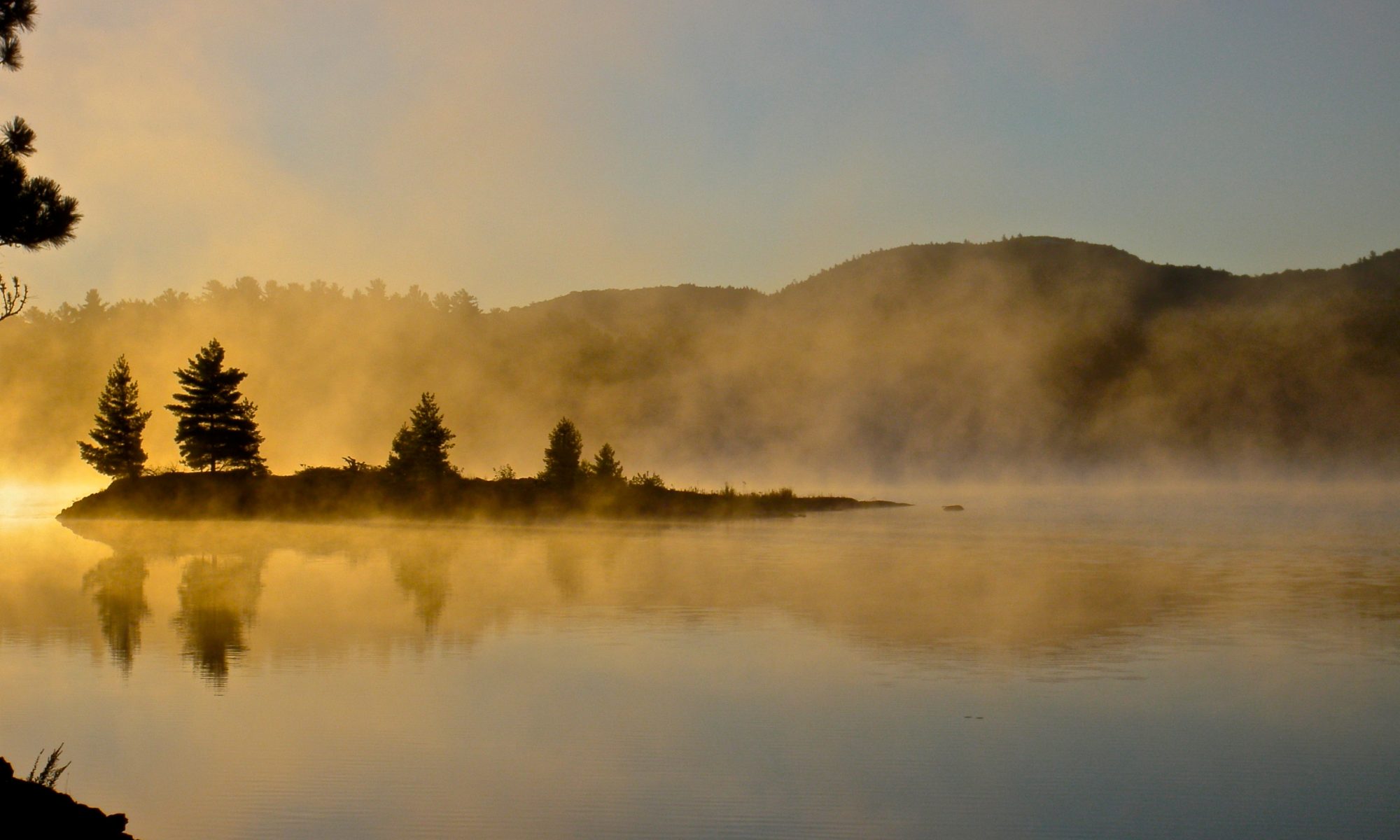
The cool air had left the warm lake steaming, and we had a lovely paddle across St Andrews Lake in the mist. We were quite surprised when a bush plane, complete with canoe strapped to a float, took off from nearby Stratton Lake and flew almost directly overhead as we neared the portage.
When we reached the end of the portage the sky had turned grey again and we could hear some ominous rumblings from the clouds. The rain started again and so once more we set up the tarp. We started counting the time between rumbles hoping that it would soon be safe enough to go on the water. We held another vote on whether or not we should proceed, and this time I insisted that we have a consensus before we left.
After over an hour of waiting we decided to chance it. We downed the last of the rum straight up for courage and loaded the canoes again. No sooner had we put the canoes in the water, and cleared the rocks and logs that obstructed the channel, than we saw a huge fork of lightning light up the whole sky in front of us.
We decided to press on to the end of the marsh and take shelter at the campsite at the southeast end of the lake near the mouth of the channel, hoping that it was unoccupied. We saw several more lightning bolts before we covered the short distance to the lake, and the bush plane buzzed us once more.
When we reached the wide open expanse of Stratton Lake we could see the dark clouds coming our way. The campsite was occupied, and we asked the couple who were camped there if they knew of a place we could weather out the storm, hoping that they’d get the hint. At first they played dumb and tried to convince us that we’d be fine, but when another huge fork of lightning lit up the sky behind where we were floating just off their beach they invited us ashore and offered to let us stay the night and have some of their food if necessary.
We just pulled the canoes on shore at first, but we could soon see sheets of rain obscuring the far end of the lake. We quickly pulled our gear under their tarp and flipped the canoes over just minutes before a deluge of biblical proportions swept over the beach.
It took about twenty minutes for the rain to run out, but when it did the clouds parted and we saw a beautiful sunset through the gap. We decided to continue back to the campground rather than camp out for another night on Stratton Lake even though it was 9PM. The last portage would be easy to cross in the dark and as long as the weather held we would be fine.
The dusk continued to fade as we paddled across the long lake until it was completely dark save for the light of the stars above. There were clouds on the horizon, but the sky overhead was completely clear. The lake was utterly calm, and paddling the canoe across the still water was like gliding across a black mirror. Occasionally we spotted flashlights from the campsites on shore, and at one point we were surrounded by a family of loons calling to each other. A beaver swam with us for a while. We could barely see him, but every few minutes we’d hear him slap his tail loudly on the water as he dove. We saw several shooting stars, including one that was large enough that we could see the ragged shape of the fireball and the edges of the yellow flame were tinged with red.
It was so black that we had to rely on the GPSr to navigate. At one point we realized that we were following the wrong shore of the lake and had to switch sides. We could spot rocks and logs jutting above the surface, but Stratton is littered with rocks and deadheads just below the waterline, and we grounded out on a few of those. When we got to the rocky channel to Grand Lake we pulled out the flashlights to scan the bottom and used the GPSr to retrace our path from the previous day.
The portage around the dam was accomplished quite easily with flashlights, and then we turned them all off for a few minutes to look at the stars and the milky way. We navigated the last channel in the dark with only a few errors, and then we could see the distant lights of Achray to guide us back. There were some ominous flashes on the horizon from distant lightning, but the sky overhead was clear and the flashes we saw were so far away that we couldn’t even hear the thunder so we pressed on.
Conclusion
Once we reached the beach we had to pack the car, change our wet clothes, and tie both canoes on the roof. It was after 1AM when we made it to the outfitters where we returned the canoe by lowering it over the fence with a rope. It was so late that we couldn’t find a gas station, and eventually had to park at a closed station on highway 7 waiting for them to open. It only took half an hour before we could fill the tank and continue on, but by the end of the 8 hour trip we were exhausted.
I had a hard time dealing with our failure to actually see the Barron Canyon. It was after all the destination of the trip, and I was a frankly devastated that we had to turn back. I didn’t want to sour the trip with my disappointment, and I didn’t want to think “It was nice but…” every time I remembered the trip. There was much to appreciate about our experience and I didn’t want to lose sight of that.
We enjoyed each other’s company, we challenged ourselves dealing not only with the portages but with the weather, and we saw some great scenery. The entire area we travelled was shaped by the same colossal forces that formed the Barron Canyon itself, and they show the scars in the form of some very tortured and beautiful terrain.
In the end I realized that being disappointed in not attaining our goal wasn’t incompatible with enjoying everything else the trip had to offer.
Tips
- Don’t underestimate the time it takes to complete the Barron Canyon loop. It’s not very far on the map, but lots of small portages can slow you down, particularly when water levels are low. Best to leave early in the day.
- Consider a through trip where you take out at the Squirrel Rapids or put in at Brigham Lake if you absolutely want to see the Canyon.