Planning a snowshoe trip in the early spring can be a bit dicey. Aside from the obvious risk of not having any snow, it’s even more likely that the lakes that would normally be traversable are not. This route is one I’d cooked up a few years ago for another late season trip. By climbing the ridge of hills at the northeast end of George Lake we have the option to avoid crossing the ice entirely by crossing at the Freeland Lake portage. It’s also a considerably easier trip than most of our other snowshoe adventures, and after our very difficult return to teardrop lake last month something a bit easier was in order. Still, the last time we attempted this route, Mike and I felt a bit cheated because it had been a bit too easy, so we decided to lengthen it a bit.
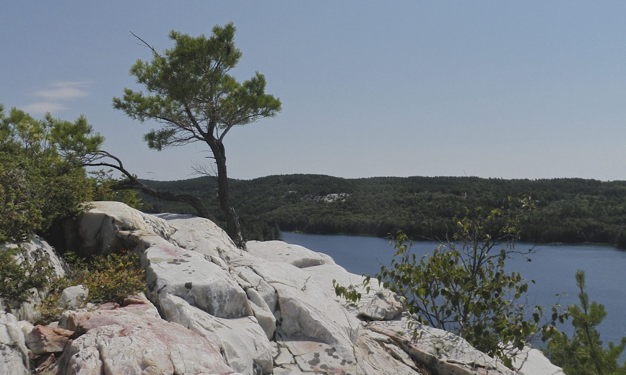
The rounded peaks of Killarney Ridge form the backdrop for the stunning views visible from the campsites on the north shore of OSA Lake, and I wanted to explore them close up. The first time we did this trip our destination was the tallest peak on this section of hill. There are two peaks, but the map labels one as being the tallest. We walked right past the first peak. We had a nice hike that day, complete with great scenery and several misadventures, but I’ve always kind of regretted not climbing the first peak. This time we were planning to climb both of the main peaks, as well as any other lumps of rock we might encounter along the way. Since it’s an easier trip I was hoping to explore as much as possible.
First Peak
We followed the Silhouette Trail from George Lake campground to Little Sheguiandah Lake. It became pretty evident that there was no shortage of snow in Killarney, and while there were a few open spots near shore the park staff informed us that the ice on George Lake was around twelve inches thick so we took the quick route across the ice to the base of the hill. Unlike our last trip the snow was almost perfect. We’d had several warm days and the snow was now dense and crunchy. Our snowshoes floated on top and barely sank in at all. For most of the trip the snow seemed like it was only a few inches deep, but every once in a while it would collapse and we’d sink in to our knees. A unique challenge on this trip was air pockets formed where rocks melted the adjacent snow. Just as I’d navigate a particularly tricky step the snow would give way and my foot would drop into a narrow crevasse between the rock and the snow wedging itself in place. But compared to our last trip the snow was a dream to walk on! Breaking trail was almost as easy as following someone else.

It’s a good thing that the snow was so much easier, because we really made the climb as hard for ourselves as we could. The last time we did this trip we followed a circuitous route up the hill to make the climb more gradual. This time I was hoping to retrace the route in reverse and climb up the steep side of the hill. The slope was indeed very steep where started to go up, and Mike, Andy and I debated going the easy way or the hard way briefly. Mike always votes for the hard route, and Andy and I were also both game so we started up.
This is far from the hardest trip we’ve done, but I’m pretty sure that this was the steepest sustained climb we’ve ever done. My heart had been pounding back on the Silhouette Trail, but now that we were bushwhacking up the hill I had to stop every few minutes to catch my breath. Not only was it steep, it was relentless. There was always a ridge visible just ahead, and whenever we’d reach it another ridge would be revealed behind.
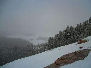
I was actually using the topo map to avoid the worst of it, but we were trying to head straight for the top so we didn’t have that many choices. And after the first fifteen minutes there was no escaping the hill. We stopped for a longer break when we spotted the first opening in the trees and we got our first glimpse of a view. As we looked out over George Lake it started to snow, large fluffy flakes that drifted down slowly. Then we were back at it, almost climbing on our hands and knees. After a particularly steep section we came to a large area of exposed craggy rock. It was so steep the snow just couldn’t stick to it.
The ancient quartzite rocks of Killarney are very smooth, but this rock was covered in handholds. I was in the lead and started to climb up with my snowshoes on. I’d carefully place one large foot on an available wedge and try to keep it in place as I pulled myself to the next handhold. The aluminum frame of my shoes slipped and scrapped across the rocks, and I could barely find room for my boots let alone the snowshoes. I almost lost my balance when I was two thirds of the way up. Mike and Andy were watching from below and debating whether they should remove their shoes. I was suffering from sunk cost fallacy, and decided to keep them on even though I advised them to take theirs off. I almost slipped a few times as I clambered the last few meters up to the safety of the snow.
I turned around and watched Mike and Andy climb up behind me. Even without snowshoes on it was a tough climb. It took us five minutes to travel just a few dozen meters, most of it vertical. We were all out of breath and needed another break at the top. It was another fifteen minutes before we pushed on again.
The next section was just as steep, until finally the ridges stopped being replaced by more hill and we could finally see what looked like a peak. It proved to be a dead end though, and we had to climb back down a short distance on the other side into a small bowl shaped depression. Mike and Andy jumped down from the rock ledge into the bowl but I walked around to find a route that would be easier on my knees. Mike felt a twinge in his back as he jumped down, and I started to worry that he’d thrown it out. As hard as it had been to get up there it would be a lot harder to get back down if Andy and I had to carry Mike! After resting for a few minutes Mike insisted that he was ok and we should push on.
The bowl was very pretty, but the far side was a wall of rock. There was a small gulley in the rocks and we followed this to the top. It was steep, but fairly climbable. One of the problems with trying to go straight up a hill is that by not following the contours of the land you have to do some extra up and down, and sure enough we had to descend one more time before we got to the top.
We crossed a wide area of bare rock where there were no trees as we approached the top of the hill. We were rounding the mountain, so our view took in George Lake to the south, but also OSA Lake to the north. It was still snowing which reduced our visibility significantly, but it was still a pretty spectacular sight. The far end of OSA Lake was barely visible through a ghostly haze of falling snow.
We lingered on the exposed ridge for a while taking in the view because the hill above us was covered in trees and we didn’t expect to be able to see anything once we reached the peak. The slope had finally eased up. We were only ten meters below the peak vertically, but over a hundred meters away, which made for a leisurely stroll to the top. As predicted, there was no view, so we didn’t linger.
It only took us an hour and forty two minutes to reach the first peak, which was the hardest part of the day. We travelled a kilometre and a half, and climbed almost 230m over some rough terrain. Other than being a bit winded on the way up I still felt pretty good, so there was lots of energy left for exploring.
Second Peak
I was planning to head north to OSA Lake, but first we were going to return to the peak that we’d visited on our last trip. I considered going north a bit first to see if we could glimpse a view in that direction, but I figured we’d pass that way later in the day. That turned out to be a bit of a mistake, but more on that later.
The two peaks are separated by a small beaver pond. The Killarney hills are dotted with these small crater lakes, and seemingly wherever one of these rocky pockets has been carved out of the hills a family of beavers have climbed up to make it a proper pond. Beavers are pretty awkward on the land, so it requires a stretch of the imagination to visualize a family of beavers climbing to make a home high up in the hills.
We circled around trying to find a path down to the pond. At one point I was quite surprised to see snowshoe tracks ahead of us, only to realize that we’d circled the peak and come across our own trail. We turned back and climbed through a narrow crack before following a gentle slope down. Once we reached the pond we were almost in the same place that we had been the first time that we visited this hill, but I had forgotten how dramatic it was. The pond is cradled in a large bowl, bordered on the far side by an almost vertical cliff that leads to the second peak. The pond is bogged over, and many dead trees rise out of the mats that cover its surface. It’s a very pretty place, and not one that sees many visitors.
The cliff is less steep on either side of the direct path to the peak, but my GPSr indicated that the last time we had climbed almost straight up on the left side of the cliff, rather than searching for an easier route. I couldn’t remember, but I suspected that Mike had been responsible for that decision the last time. After a short break to take in the view we crossed the pond and looked up at the hill.
GPSr tracks aren’t completely accurate, and even though we were very close to where we ascended last time I wasn’t positive that we had been in this exact spot. There was a wall of rock to our left, and I thought that we might have climbed on the other side of it. Mike spotted a path straight ahead and forged up the hill. He was soon blocked by vertical rock wall, so he came back down and tried another path to the right. Andy and I followed him, and this time we made it quite a ways up before we got blocked again. This time Mike turned back when there were no more trees to break his fall if he were to slip on the steep slope. We decided to retreat and try the other side of the rock ledge to the left of the cliff.
We had to walk all the way down to the ice to circumnavigate the ledge. I was in the lead with Mike close behind me. When I turned to head in to shore again I felt the ice start to give way beneath my feet, so I jumped and lunged for solid ground. Almost at the same moment I heard a yell from behind me as the ice gave way beneath Mike. I landed on solid ground and turned to see my footprint filling with dark water, and Mike dashing two steps across the ice to make it to shore. Mike and I were both panting on shore as his footprints filled with water.
Bogs are notorious for soft ice. The ice had felt pretty good on this pond so far, but the warmth from the rotting bog matter combined with the extra heat gathered by the rocks near shore had made the ice dangerously thin. Andy was still behind us, so we advised him not to come ashore where we had, and to swing wide and then make a direct path for land. He took our advice, but the ice gave way beneath him when he was even further from shore. He made a dash, and left several wet footprints filling with water. For a moment I thought we’d have to grab him and haul him on shore, but he managed to make it. He got the worst soaker of the three of us. Even though his feet were wet, he didn’t complain all day, and eventually the water in his boot warmed up.
This section of hill was much easier to climb, but still not easy. I had to stop repeatedly to catch my breath on the way up, but at least it was climbable. We finally got to the top of the steep slope, and then it was a fairly short and easy walk to the top of the hill. There’s one little mound of rock right at the top of the hill, and that marks the highest point. There was just enough room for all three of us to balance on this rock and claim the peak summited. This peak may technically be slightly taller than the other one, but according to my GPSr the difference is less than a meter, and the first peak we visited has a much better view. Not only are there more trees obscuring the view on this peak, when we did glimpse a brief window between the trees, all we could see was white. The falling snow obscured the view in all directions. We wandered around looking for a view, but the only thing we could see was the beaver pond that we’d just crossed.
Third Peak
To descend the hill we followed the ridge below the peak rather than climbing back down to the beaver pond. The ridge follows the northeast shore of the pond and slopes down gradually. It would be a much easier way to climb to the peak than the vertical ascent up the edge of the cliff that we took.The snow was still coming down, but I was keeping my eyes peeled for a lookout that might give us a view. I finally spotted a likely looking spot, and we took a short detour. It was still snowing, but the visibility had improved and we were rewarded with a sweeping vista that encompassed both Killarney Lake and OSA Lakes. We were at the top of a tall cliff that was definitely not climbable. Far below us a sea of trees stretched off into the distance toward the shore of Killarney Lake.
We continued to follow the edge of the cliff, and we did glimpse a couple of other views, but none as spectacular as the first one. The ridge finally brought us down to the end of the pond where the beaver had built his dam. We crossed the creek that ran down the hill and then continued north towards OSA Lake. At this point we were circling around the base of the first peak that we’d climbed. I was hoping to reach one of the exposed rock ledges that’s visible from the far shore of the lake. I was trying not to descend too far because I didn’t want to have to climb back up, but the hill was getting steeper and steeper at our altitude.
We finally decided to descend into the shallow valley cut by the stream that was draining the pond that was now above us. As we walked away from the base of the hill the full extent of the rock face we had been circumnavigating was revealed to us. We were at the base of a very tall cliff. The top was an open ridge that would offer a spectacular view to the north. Not long ago we’d been on the peak above the cliff, just 40 meters from the edge. The view had been blocked by trees, but I’d hoped that we’d see it on the way down. From where we were there was no way to climb back up the vertical face of rock. I was kicking myself for not exploring the north of the peak before we descended down to the pond because it was impossible now.
We decided to continue down the valley, but then I noticed another lump of rock in front of us. It wasn’t nearly as tall as the cliff behind us, but it did face the lake and it was mostly bare rock. We took a short detour, and after a bit of climbing found ourselves perched atop yet another cliff looking out over OSA Lake. Even though we weren’t as high, the view was spectacular, and we lingered for a while enjoying the scenery.
There was another ridge that I’d hoped to explore, but the valley kept pushing us down towards the lake. At first I tried to fight it, but then we gave in and followed the creek down the hill. There was a small waterfall, and then we began to loose elevation very rapidly. It was actually hard to climb down the hill here because the muscles in my thighs were constantly having to fight the tendency to tumble down the slope.
OSA Lake
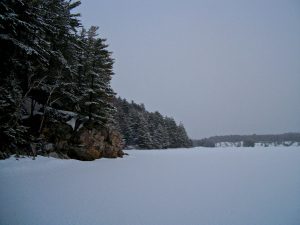
We finally made it down to the ice, but we were further east than I had expected. We decided to walk along the ice back to the trail that returns to George Lake. We almost visited OSA a few years ago this way, but we didn’t follow the trail all the way to the end. I’ve never visited this particular bay on the south side of the lake, I usually stick to the islands in the centre or the ridge along the north shore. There’s a campsite nearby, but I’ve never visited it. Granted, it isn’t as scenic as the north shore of the lake, but it’s still a pretty spectacular spot.
Walking on the lake was very easy, which gave us lots of time to take in a different perspective on the landscape that we’d just seen from above. I hadn’t really expected much from this part of our trip, but there was a lovely stillness down on the lake. It actually reminded me of being on a canoe trip, since we were travelling along the surface of the lake and hunting for a portage.
I didn’t have a map of where the old portage is, but I did have our track from the last time we visited the area. I remembered seeing the lake from the trail on that trip so I didn’t think that it would be hard to find the trail at all, but we hunted around for quite a while. We finally just bushwhacked into the woods. Mike found a small path through a valley between the hills and we followed that.
I’m not sure why this portage was abandoned, there are certainly tougher ones in the park. But it is pretty easy to paddle around the ridge in the summer travelling from George to Freeland, to Killarney and finally to OSA Lake. The trail is very steep at both ends, but relatively flat in the middle, and we soon found ourselves climbing up this steep section. The hill looked like a wall of snow in front of us, and I was soon breathing hard again. This was the first climbing we’d done in a while, and I could feel the muscles in my thighs beginning to cramp up. I stopped to rest, but not long after I got moving again they started to seize up again. I stopped and started several times to give my legs a rest, and each time I paused the aching ebbed. I could see the top of the hill ahead, tantalizingly close.
The charley horses in my legs stopped and my breathing became more regular as soon as we reached the flat portion of the trail. I was pretty relieved since we still had several kilometres to go to reach the car. Navigating in this valley was pretty easy, but the valley is wide enough that it’s possible to get going in the wrong direction. It didn’t seem like it took us long at all to reach George Lake. We were at the top of another steep hill looking down over an exposed rock face. The rock was too steep to climb so we went around it and zig zagged back and forth a few times before we were finally on the ice again.
George Lake
Often we’re pretty beat by the end of one of these trips. Today had been one of our longer trips, but the snow conditions were ideal and other than the initial climb it hadn’t been particularly difficult. Walking back on George I never felt the need to stop to catch my breath, and my legs didn’t show any more signs of cramping until we had almost returned to the campground. Thanks to the longer days at this time of year it was still quite light by the time we returned to the car, and we could just see the sun setting through the trees as we changed for the long drive home.
Tips
- If you do this as a day trip you’ll have to purchase a day pass from the park office for parking your vehicle.
- If you do the trip in the winter you can rent snowshoes from The Friends Of Killarney Park at the camp office where you pick up your permit.
- This trip is an excellent snowshoe trip, but it would also make a great day excursion while camped on Killarney or OSA Lakes. It would also be possible to do it as a day trip in the summer by canoeing across George Lake or by hiking around George and crossing the George — Freeland portage (though that could be challenging).
- There are some excellent views from the western side of the western peak, but if you do ascend, make sure to explore to the north as well. We missed this spot and it looks like it was pretty spectacular.
- The eastern peak doesn’t have a view from the top, but the northern ridge that leads to this peak does have some excellent viewing opportunities.